")

1819 · London
by John Cary
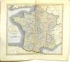
London: John Cary, 1819. Near Fine binding. Hand-colored map, 21.5 x 25.25"; unbound; by the famed British cartographer and engraver.~~Showing France, Agreeable to its Divisions into Provinces, as Previous to the Revolution from the Latest Authorities. There is the beginning of separation at the bottom of the fold, along with a short closed tear of about 2". Still, a lovely map, highly detailed and delicately colored. Near Fine binding.
(Inventory #: 293034)

![[ARCHIVE] [BRITISH NAVY] BURSAR'S LOG AND ORDERS RE VICTUALLING FRENCH PRISONERS, 1743-1744](https://d3525k1ryd2155.cloudfront.net/h/400/282/1601282400.0.m.jpg)
![[ENGLISH HISTORY] REASONS AGAINST A WAR WITH FRANCE, OR AN ARGUMENT SHEWING THAT THE FRENCH KING'S OWNING THE PRINCE OF WALES AS KING OF ENGLAND, SCOTLAND AND IRELAND; IS NO SUFFICIENT GROUND OF A WAR](https://d3525k1ryd2155.cloudfront.net/h/396/282/1601282396.0.m.jpg)