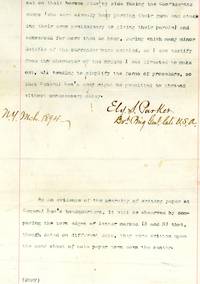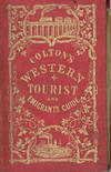

by Fisher, Richared S., M.D.,
New York: J. H. Colton and Company, 1857, 16mo, xii, [13] – 149, 37 pp., catalog of Colton's publications, large folding colored map, measuring 53.5 x 72 cm, entitled: Guide Through Ohio, Michigan, Indiana, Illinois, Missouri, Wisconsin, Iowa, Minnesota, Nebraska & Kansas. Showing the Township lines of the United States Surveys, Locations of Cities, Towns, Villages, Post Hamlets, Canals, Rail and Stage Roads. By J. Calvin Smith. Published by J. H. Colton & Co., 1857, bound in original red cloth, binding somewhat worn, head of spine chipped with loss, contemporary ownership signatures, former owner's bookplate, map is in good condition with some separations at fold joints, right hand edge of map slightly ruffled, else very good.
The detailed map shows the territory from the extreme western edge of Pennsylvania across the mid-west to Kansas, portions of Nebraska and Minnesota Territory. (Inventory #: 31133)
The detailed map shows the territory from the extreme western edge of Pennsylvania across the mid-west to Kansas, portions of Nebraska and Minnesota Territory. (Inventory #: 31133)