A New American Atlas containing Maps of the Several States of the North American Union, projected and drawn on a uniform scale from documents found in public offices of the United States and State Governments, and other original and authentic information by Henry S. Tanner
- Folio
- Philadelphia: H.S. Tanner, 1825
Philadelphia: H.S. Tanner, 1825. Folio. (23 1/2 x 16 1/2 inches). Letterpress half-title, 1p. index and 18pp. text. Engraved title with vignette of the "First Landing of Columbus in the New World, 21 fine hand-coloured engraved map sheets (16 maps on 16 double-page sheets; 1 map on one folding sheet; and 1 map on 4 double-page sheets), some expert restoration to corners. Expertly bound to style in half brown straight-grained morocco over contemporary marbled paper-covered boards, the flat spine divided into six compartments by double gilt rules, lettered in the second compartment, the others with repeat decoration in gilt, contained within a modern red morocco-backed cloth box, the spine in seven compartments with raised bands, lettered in the second, the others with repeat tooling in gilt
A fine copy of the improved second edition of "one the most magnificent atlases ever published in the United States" (Ristow).
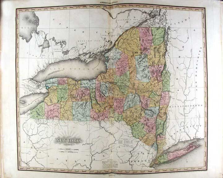
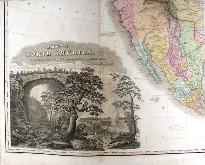
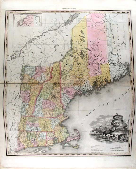
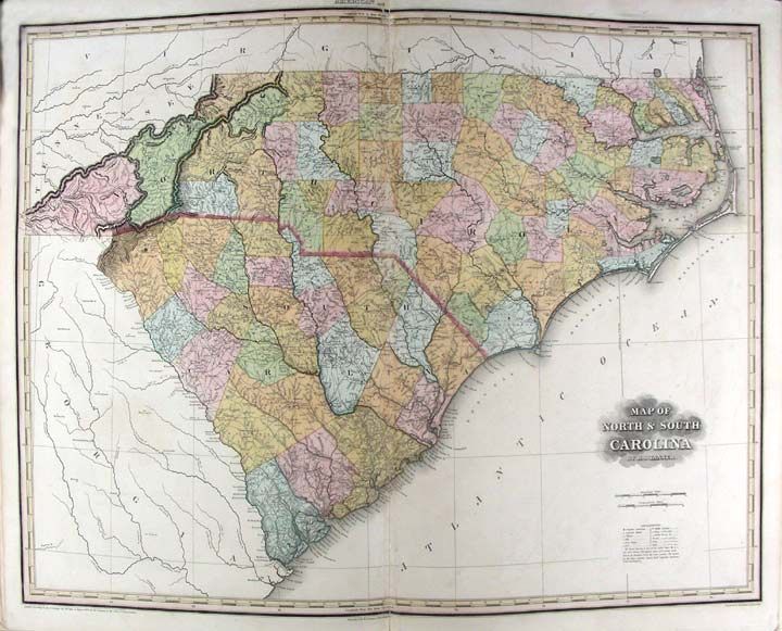
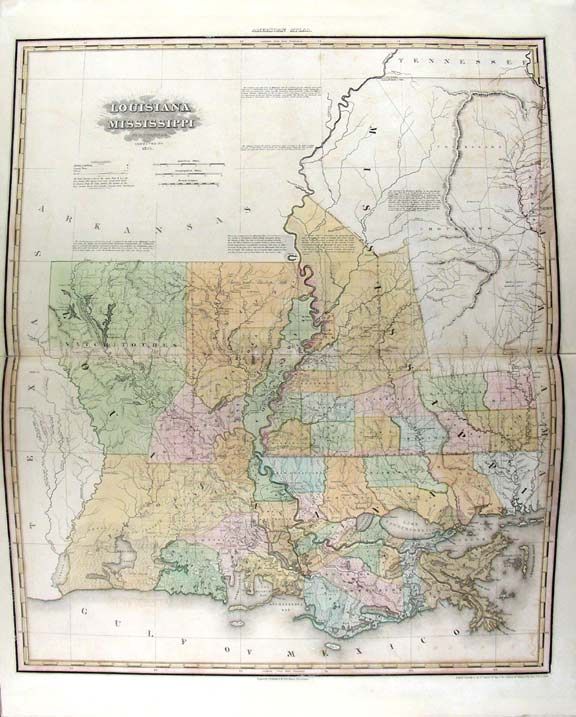
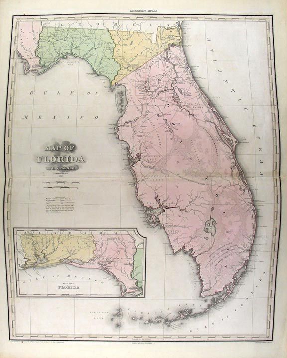
Tanner's New American Atlas contained the most accomplished series of maps of America that had yet appeared in an atlas. Of the greatest importance were the maps of American states, which were highly detailed and brilliantly coloured. While New York and Florida each had their own dedicated page, other double-page sheets showcased multiple states at a time. As the title claims, these maps were drawn up using a careful combination of original surveys and the best existing published sources. The evident high cost of production meant that the publishers took the decision to issue the maps originally in five separate parts which were published from 1819 to 1823. A first collected edition was published in 1823, and this second revised edition appeared in 1825. The maps, all of which are carefully hand-coloured, include a world map, 4 maps of continents, a map of South America on a large folding sheet made up from two joined sheets (the index calls for two separate sheets), a map of North America on 4 sheets and 11 double-page maps of the various States. The very large map of North America is of particular beauty and note. Wheat writes: "This map was a landmark - a great cartographical achievement ... Tanner made good use of a large number of intervening map, those of interest here being Humboldt's 'New Spain,' Pike's various maps, Long's map, and 'Pedro Walker's Map of New California ... This 1822 map of North America was the progenitor of a long line of famous maps" (Wheat, II: pp. 82-87) Contemporary reviews were favourable: the New American Atlas "is decidedly one of the most splendid works of the kind ever executed in this country" (United States Gazette, September 1823). Never "has either America or Europe, produced a geographical description of the several States of the Union, so honorable to the Arts, and so creditable to the nation as Tanner's American Atlas." (National Advocate 25 August 1824). Perhaps the most enthusiastic report came from the scholar Jared Sparks who wrote in the April 1824 issue of the North American Review that "as an American Atlas, we believe Mr. Tanner's work to hold a rank far above any other, which has been published." This second edition is notable for the significant cartographic changes made by Tanner, reflecting new boundaries, counties, towns and discoveries since the initial maps were published. For example, the map of Illinois shows significant changes to the mapping of the headwaters of the Mississippi, and the map of Louisiana depicts Indian lands with vast changes from the first edition.
Howes T29; Phillips 3669; cf. Ristow, American Maps and Map Makers, pp. 193-198; Rumsey 2755; Sabin 94323.
A fine copy of the improved second edition of "one the most magnificent atlases ever published in the United States" (Ristow).
Tanner's New American Atlas contained the most accomplished series of maps of America that had yet appeared in an atlas. Of the greatest importance were the maps of American states, which were highly detailed and brilliantly coloured. While New York and Florida each had their own dedicated page, other double-page sheets showcased multiple states at a time. As the title claims, these maps were drawn up using a careful combination of original surveys and the best existing published sources. The evident high cost of production meant that the publishers took the decision to issue the maps originally in five separate parts which were published from 1819 to 1823. A first collected edition was published in 1823, and this second revised edition appeared in 1825. The maps, all of which are carefully hand-coloured, include a world map, 4 maps of continents, a map of South America on a large folding sheet made up from two joined sheets (the index calls for two separate sheets), a map of North America on 4 sheets and 11 double-page maps of the various States. The very large map of North America is of particular beauty and note. Wheat writes: "This map was a landmark - a great cartographical achievement ... Tanner made good use of a large number of intervening map, those of interest here being Humboldt's 'New Spain,' Pike's various maps, Long's map, and 'Pedro Walker's Map of New California ... This 1822 map of North America was the progenitor of a long line of famous maps" (Wheat, II: pp. 82-87) Contemporary reviews were favourable: the New American Atlas "is decidedly one of the most splendid works of the kind ever executed in this country" (United States Gazette, September 1823). Never "has either America or Europe, produced a geographical description of the several States of the Union, so honorable to the Arts, and so creditable to the nation as Tanner's American Atlas." (National Advocate 25 August 1824). Perhaps the most enthusiastic report came from the scholar Jared Sparks who wrote in the April 1824 issue of the North American Review that "as an American Atlas, we believe Mr. Tanner's work to hold a rank far above any other, which has been published." This second edition is notable for the significant cartographic changes made by Tanner, reflecting new boundaries, counties, towns and discoveries since the initial maps were published. For example, the map of Illinois shows significant changes to the mapping of the headwaters of the Mississippi, and the map of Louisiana depicts Indian lands with vast changes from the first edition.
Howes T29; Phillips 3669; cf. Ristow, American Maps and Map Makers, pp. 193-198; Rumsey 2755; Sabin 94323.
Details
Title
A New American Atlas containing Maps of the Several States of the North American Union, projected and drawn on a uniform scale from documents found in public offices of the United States and State Governments, and other original and authentic information by Henry S. Tanner
Author
TANNER, H.[enry] S.[chenck] (1786-1858)
Binding
Folio
Condition
Unknown
Publisher
H.S. Tanner: Philadelphia
Date
1825