1845 · Philadelphia
by Wilkes, Charles
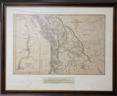
Philadelphia, 1845. Very good. Stereotyped map of Oregon, highly detailed, neat line to neat line: 59 x 90 cm. Inset map of Columbia River, neat line to neat line (irregular shape): 54.4 x 24 cm. Scattered foxing and creasing where formerly folded, generally a very good copy. Matted in a handsome maple frame (not examined outside frame). THE FIRST OFFICIAL MAP OF THE NORTHWEST. It was in many respects the most detailed of this extensive area yet published, and for the main Oregon regions and the Hudson's Bay Company's territories to the north it was an accurate, quite extraordinary map. "The areas now embraced by Oregon, Washington, and Idaho are very (truncated)


![[WOMEN IN THE WEST]. Covered Wagon Women. COMPLETE SET of 11 vols., DELUXE ISSUE (vols. 1-9 and 11) limited to 33 copies in gold-tooled leather, and trade edition (vol. 10) in cloth](https://d3525k1ryd2155.cloudfront.net/h/100/548/1687548100.0.m.jpg)
![[WOMEN IN THE WEST]. Covered Wagon Women. COMPLETE SET of 11 volumes bound in original publisher's cloth](https://d3525k1ryd2155.cloudfront.net/h/099/548/1687548099.0.m.jpg)