Carousel content with 1 slides.
A carousel is a rotating set of images, rotation stops on keyboard focus on carousel tab controls or hovering the mouse pointer over images. Use the tabs or the previous and next buttons to change the displayed slide.

-
 Slide 1:
-
 Slide 2: no title
 -
 Slide 3: no title
 -
 Slide 4: no title
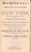
1882 · Chicago
Chicago: Rand, McNally & Co, 1882. Pocket map of New York State, printed in colors, approx. 30" x 32" overall size. Map and 118 pages of index contained in the publisher's dark green textured cloth binding, approx. 4 1/4" x 7" size; cover titles brightly gilt. Light wear to the binding; couple short splits along map-folds, a little browning; in very good condition. The title page explains that full postal mailing details are also included, "...for sending mail matter to every place not a post office, in the state, known in the post office department as "locals." Also, an Alphabetically Arranged List of all Railroads in the State, (With the name of (truncated)

