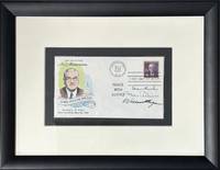
Carousel content with 1 slides.
A carousel is a rotating set of images, rotation stops on keyboard focus on carousel tab controls or hovering the mouse pointer over images. Use the tabs or the previous and next buttons to change the displayed slide.

-
 Slide 1:
-
 Slide 2: no title
 -
 Slide 3: no title
 -
 Slide 4: no title
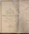
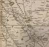
1822 · London
by STEEL, Penelope
London: J.W. Norie, 1822. Map. Uncolored engraving. 22 x 76 1/4 inches. (one of two sheets).
This large 1822 map is the top half of Steel's sea chart of the Indian Ocean and Pacific Ocean. Even though this map is only the top portion, it includes most of the land areas depicted on the full map--North and East Africa, Arabia, India, Southeast Asia, the East Indies, Singapore, and the Philippines--and is absent only the southern part of Africa and Australia. The map is very detailed with cities, islands, and trade routes. Annotations throughout provide insight into contemporary knowledge of the region, particularly in regards to the many small (truncated)
This large 1822 map is the top half of Steel's sea chart of the Indian Ocean and Pacific Ocean. Even though this map is only the top portion, it includes most of the land areas depicted on the full map--North and East Africa, Arabia, India, Southeast Asia, the East Indies, Singapore, and the Philippines--and is absent only the southern part of Africa and Australia. The map is very detailed with cities, islands, and trade routes. Annotations throughout provide insight into contemporary knowledge of the region, particularly in regards to the many small (truncated)