Carousel content with 1 slides.
A carousel is a rotating set of images, rotation stops on keyboard focus on carousel tab controls or hovering the mouse pointer over images. Use the tabs or the previous and next buttons to change the displayed slide.

-
 Slide 1:
-
 Slide 2: no title
 -
 Slide 3: no title
 -
 Slide 4: no title
 -
 Slide 5: no title
 -
 Slide 6: no title
 -
 Slide 7: no title
 -
 Slide 8: no title
 -
 Slide 9: no title
 -
 Slide 10: no title
 -
 Slide 11: no title
first edition
1850 · Washington DC
by Smith, Martin Luther & Edmund La Fayette Hardcastle. U.S. Secretary of War (Marcy)
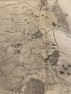
Washington DC, 1850. First Edition. Good. Text: 8vo (224 x 140 mm). 14, [2] pp. (including final blank leaf), some foxing. COMPLETE WITH LARGE FOLDING LITHOGRAPH MAP OF MEXICO, with U.S. Army routes in red (659 x 500 mm). Folds and short repairs where attached to text, light browning. Recent sympathetic drab wrappers, front cover lettered in manuscript. First edition of this excellent map illustrative of both the Mexican-American War and the cartography of Mexico, prepared by members of the U.S. Army Topographical Engineers. Our map is accompanied by the essential text which is not always present. Herein "cartographer M.L. Smith (Lieutenant of the Topographical (truncated)
![[WOMEN IN THE WEST]. Covered Wagon Women. COMPLETE SET of 11 vols., DELUXE ISSUE (vols. 1-9 and 11) limited to 33 copies in gold-tooled leather, and trade edition (vol. 10) in cloth](https://d3525k1ryd2155.cloudfront.net/h/100/548/1687548100.0.m.jpg)
![[WOMEN IN THE WEST]. Covered Wagon Women. COMPLETE SET of 11 volumes bound in original publisher's cloth](https://d3525k1ryd2155.cloudfront.net/h/099/548/1687548099.0.m.jpg)