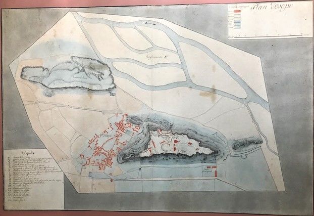
Watercolor ground plan (drawn to scale) of the cantonment of French troops in the Italian town of Osoppo and its fortress in the late 18th century
- Not bound.
- ca1800
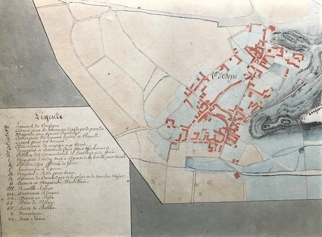
ca1800. Not bound.. Very good; colors somewhat faded; mounted; folded at one point.. Folio, measuring 492 x 730 mm. Utilizing 7 different colors to designate grounds, buildings, emplacements, roads, barriers, water courses etc. with a 20 line legend and scale of distance (upper right corner). The map bears an internal date (for an identified location on the map) of 1797, i.e., the named location is given with a date implying an unstated "as of".
The Italian town of Osoppo sits northwest of Udine and demarcates the western most point of defense for the old Venetian Republic that ended with the French - Austrian Treaty of Campo Formio ceding Venice to Austrian rule. Napoleon himself is supposed to have sat at the heights of the fortress in Osoppo and opined that it was a natural barrier and defensive point for all travel from the Alps down to the coast. Hence its occupation by the French. The Treaty proved short-lived and the fortress changed hands a number of times between 1797 and 1814. It appears that this plan follows from a French occupation and reveals numerous details of that occupation and its strategic importance. Beginning in the early 16th century a fortress had been established on the high ground; here the Casa Savoignano is placed and identified apparently as a reminder of this legacy.
The Italian town of Osoppo sits northwest of Udine and demarcates the western most point of defense for the old Venetian Republic that ended with the French - Austrian Treaty of Campo Formio ceding Venice to Austrian rule. Napoleon himself is supposed to have sat at the heights of the fortress in Osoppo and opined that it was a natural barrier and defensive point for all travel from the Alps down to the coast. Hence its occupation by the French. The Treaty proved short-lived and the fortress changed hands a number of times between 1797 and 1814. It appears that this plan follows from a French occupation and reveals numerous details of that occupation and its strategic importance. Beginning in the early 16th century a fortress had been established on the high ground; here the Casa Savoignano is placed and identified apparently as a reminder of this legacy.
Details
Title
Watercolor ground plan (drawn to scale) of the cantonment of French troops in the Italian town of Osoppo and its fortress in the late 18th century
Author
Anon. <br />
Binding
Not bound.
Condition
Very Good
Date
ca1800