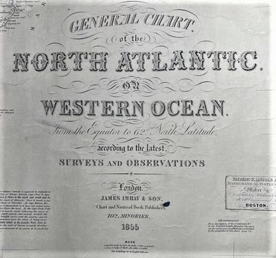
General Chart of the North Atlantic. Or Western Ocean. From the Equator to 62o North Latitude according to the latest Surveys and Observations
- As issued.
- London: James Imray & Son ... 102 Minories, 1855
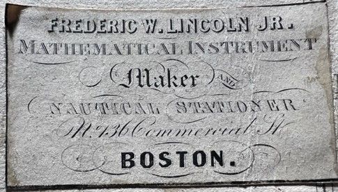
London: James Imray & Son ... 102 Minories, 1855. Revised Edition.. As issued.. Very good; some minor punctures and a repaired tear (cloth patch on verso).. Folio. Blue back sea chart with quarter inch cloth binding along all borders. It meas. appx. 39.5 x 52 inches. The chart also carries, near the cartouche, the applied label of Frederic Lincoln, instrument maker, in Boston. Imray's identifying label mounted on the verso.
The chart covers the Atlantic from southern Greenland to Dutch Guiana and the Yucatan to what is today Nigeria. There are 2 large inset surveys for Long Island and Funchal Bay. The chart first appeared in 1849 with revisions offered as required. Imray was in business with James Hutton, the chronometer and watch-maker, who operated out of the same premises. Worms, pp. 339-340.
The chart covers the Atlantic from southern Greenland to Dutch Guiana and the Yucatan to what is today Nigeria. There are 2 large inset surveys for Long Island and Funchal Bay. The chart first appeared in 1849 with revisions offered as required. Imray was in business with James Hutton, the chronometer and watch-maker, who operated out of the same premises. Worms, pp. 339-340.
Details
Title
General Chart of the North Atlantic. Or Western Ocean. From the Equator to 62o North Latitude according to the latest Surveys and Observations
Author
SEA CHART - James Imray & Son
Binding
As issued.
Condition
Very Good
Publisher
James Imray & Son ... 102 Minories: London
Date
1855
Edition
Revised Edition.