Carousel content with 1 slides.
A carousel is a rotating set of images, rotation stops on keyboard focus on carousel tab controls or hovering the mouse pointer over images. Use the tabs or the previous and next buttons to change the displayed slide.
")
-
 Slide 1:
-
 Slide 2: no title
 -
 Slide 3: no title
 -
 Slide 4: no title
 -
 Slide 5: no title
 -
 Slide 6: no title
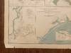
first edition
1890 · New York
by Bien, Julius
New York: Julius Bien & Co. (for the U.S. War Dept.), 1890. First Edition. Good. Original lithograph: folio map (image size: 29" x 18") unframed. Edges with some chipping or loss in the margins (SEE IMAGES), tear along fold at top edge extending ca. 4.5"). An informative map of the Coast of Texas which itself contains ten maps, the largest of which covers the coast of Texas from the mouth of the Rio Grande to Orange, the easternmost city in the state. In the largest maps there is an inset in the upper right corner, showing minor details for 14 individual forts (these are numbered on the main chart).
This is Plate LXV extracted from "Atlas (truncated)
This is Plate LXV extracted from "Atlas (truncated)
![[WOMEN IN THE WEST]. Covered Wagon Women. COMPLETE SET of 11 vols., DELUXE ISSUE (vols. 1-9 and 11) limited to 33 copies in gold-tooled leather, and trade edition (vol. 10) in cloth](https://d3525k1ryd2155.cloudfront.net/h/100/548/1687548100.0.m.jpg)
![[WOMEN IN THE WEST]. Covered Wagon Women. COMPLETE SET of 11 volumes bound in original publisher's cloth](https://d3525k1ryd2155.cloudfront.net/h/099/548/1687548099.0.m.jpg)