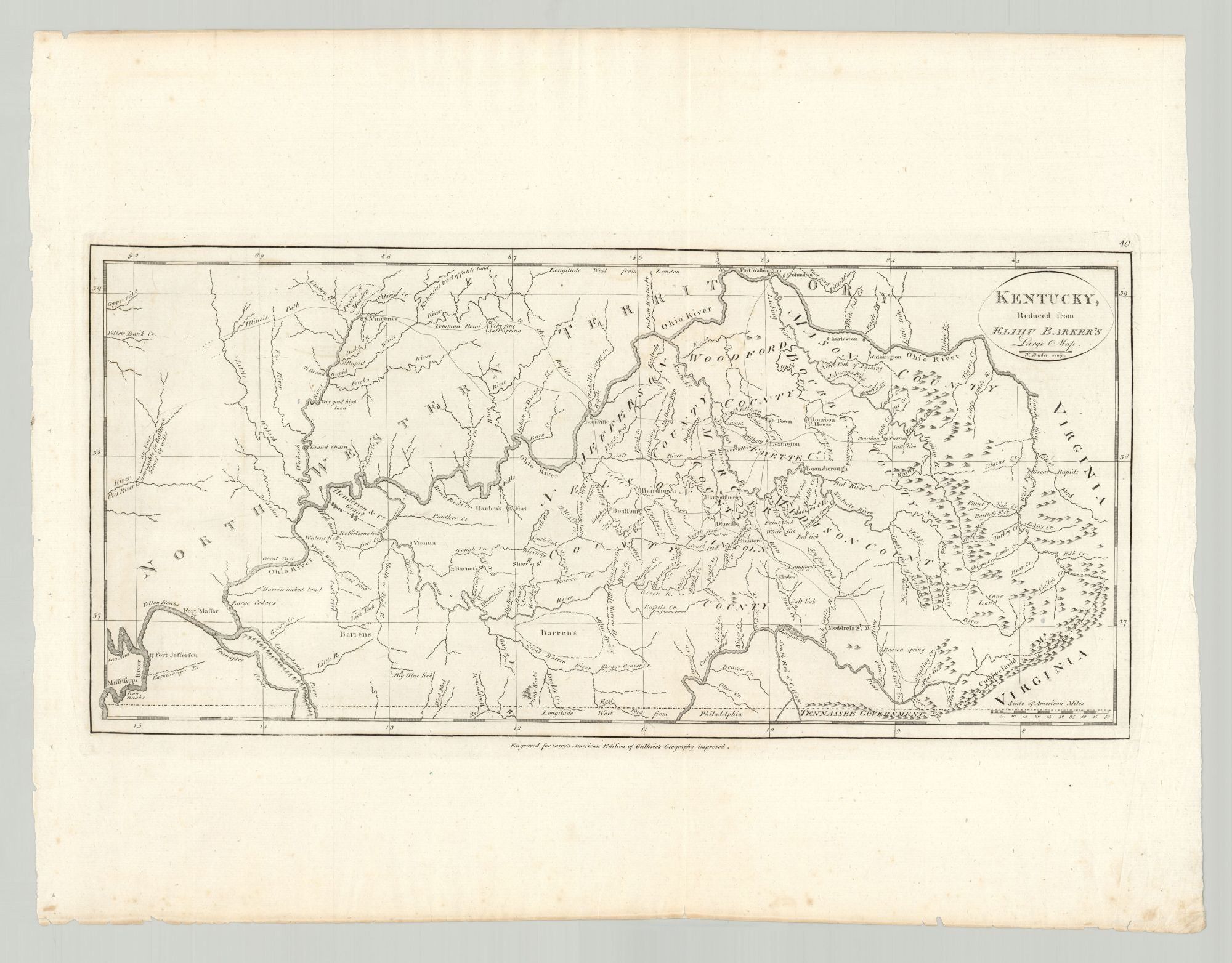
Kentucky, Reduced from Elihu Barker’s Large Map
- [Philadelphia: Mathew Carey, 1795]
The second appearance in the United States of Elihu Barker’s important map of Kentucky.
This map is a reduced version of Barker’s exceptionally rare large map of Kentucky of 1794 and appeared in Mathew Carey’s American edition of Guthrie’s Geography (1795). It shows the new state of Kentucky and its adjacent areas, including Tennessee (identified as “Tenassee Government”) to the south, “Northwestern Territory” to the northwest, and Virginia to the east. Details include roads, bodies of water, settlements, towns, counties, stations, trails, salt licks, courthouses, furnaces, mines, “fertile land,” springs, and forts. A small portion of the Mississippi River is seen in the lower-left corner and the Ohio River—the border between Kentucky and the Northwest Territory—extends across most of the map. The Henderson & Co. Grant is identified in western Kentucky. This tract was given to Richard Henderson and his Transylvania Company in 1778 as compensation for the loss of their claim in the middle of the state. Other interesting cartographic features include representations of mountains in eastern and western Kentucky; multiple regions designated as “barren naked land”; and several outlying stations (Moddrel’s Station, Shaw’s Station, and Barnett’s Station). Some of the most minute details include drainage basins and the names of the tributary creeks. The prime meridian is Philadelphia and a scale appears in the lower-right corner. Relief is shown pictorially.
While scant information exists on Elihu Barker (d. 1792), scholar Willard Rouse Jillson notes that Barker “was evidently an Englishman…who had good connections there as well as in America, and was particularly interested in the western country. His map of Kentucky was preceded by John Filson’s much distorted map of Kentucky and other of the Eastern Mississippi River Valleys, but it is by far the most accurate of the early maps of this State. It is so well done that it could be used today with satisfaction for general purposes.”
Born in Philadelphia, William Barker (1770–1805) was the son of Elihu Barker and was active as an engraver in Philadelphia in the late eighteenth and early nineteenth centuries. He appears in Philadelphia directories from at least 1795 to 1809.
Dublin-born American publisher Mathew Carey (1760–1839) ran the largest American publishing house of the nineteenth century, which he founded in 1785. Carey’s first cartographic publication appeared in 1794: A General Atlas for the Present War, based on maps from William Guthrie’s Atlas to Guthrie’s System of Geography. A year later, in 1795, Carey published The General Atlas for his edition of Guthrie’s Geography Improved, which included sixteen maps of U.S. States by Americans. Later that year these sixteen maps, along with five others, were published as Carey’s American Atlas. For this work, Samuel Lewis made many important contributions as geographer, draftsman, mapmaker and penman. Engravers included William Barker, Joseph T. Scott, James Thackery, John Vallance, Samuel Hill, Amos Doolittle and Benjamin Tanner. In 1796 Carey published his General Atlas, which included maps of the rest of the globe.
Barker’s map was also published in London in 1795 and appeared in Gilbert Imlay’s A Topographical Description (1797).
REFERENCES: Wheat & Brun 641–642; Rumsey 2862.040; Jillson, Willard Rouse. “Elihu Barker Map of Kentucky,” Register of Kentucky State Historical Society, Vol. 21, No. 63 (September, 1923), pp. 322–323.
Details
Title
Kentucky, Reduced from Elihu Barker’s Large Map
Author
Barker, Elihu; W[illiam] Barker, engraver
Condition
Unknown
Publisher
[Philadelphia: Mathew Carey, 1795]