Venice; Venezia. Venedig
- unbound
- London: SDUK, 1844
London: SDUK, 1844. unbound. W. B. Clarke. Map (in two sheets). Engraving with original hand coloring. Each image measures 15.5" x 11.5".
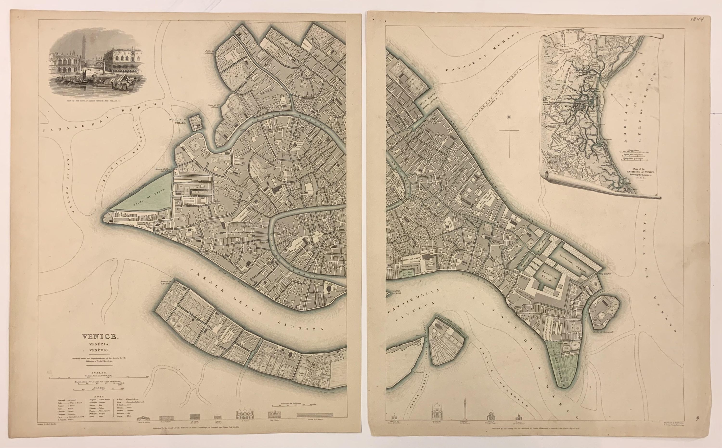
The map of Venice, issued in 1844 by the Society for the Diffusion of Useful Knowledge (SDUK), is a highly detailed, hand-colored city plan issued on 2 sheets. It features the main islands of Venice, with labeled canals, roads, alleys, churches, and public institutions. The map includes profile views of prominent buildings like the Ponte De La Rialto, Piazza Rialto, St. Mark's Basilica, and the Doge's Palace. Insets show the Piazza San Marco from the Grand Canal and a regional map of the Gulf of Venice. This plan is noted for its accuracy and artistic quality, making it one of the best 19th-century English town plans. It was drawn by WB Clarke and engraved by BR Davies, and it highlights Venice's historical context under Austrian rule and its later significance in Italian unification. The map is recognized for its completeness and is held in several prestigious collections. A set of 2 maps. In good condition with minor toning.
The "Society for the Diffusion of Useful Knowledge" (SDUK), founded in 1826 at the initiative of British lord Henry Peter Brougham, aimed to distribute affordable, high-quality educational materials to the working and middle classes. Despite ties to prestigious publishers like Baldwin and Cradock, Chapman and Hall, and Charles Knight, SDUK closed in 1848 due to financial challenges. It achieved renown for its exceptional atlases, notably a comprehensive series of maps initially issued individually and later consolidated into a groundbreaking world atlas under Chapman and Hall. SDUK maps are celebrated for their accuracy, detail, and accessibility, representing a pinnacle of 19th-century English mass-market cartography.
Details
Title
Venice; Venezia. Venedig
Author
SDUK (Society for the Diffusion of Useful Knowledge)
Binding
unbound
Condition
Unknown
Publisher
SDUK: London
Date
1844