Chart of the Harbors of Salem, Marblehead, Beverly and Manchester From a Survey Taken in the Years 1804, 5 & 6 by Nathl. Bowditch (and) Directions for Sailing Into the Harbours of Salem, Marblehead, Beverly, and Manchester.
- Newburyport, MA: Edmund M. Blunt, 1806
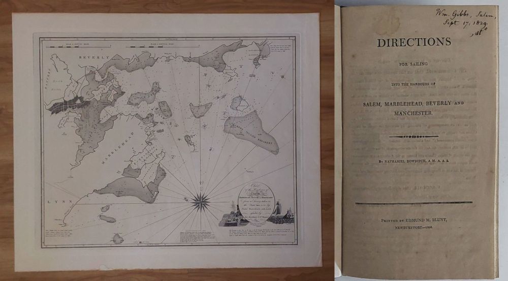
Newburyport, MA: Edmund M. Blunt, 1806. In 1806 the great navigator and mathematician Nathaniel Bowditch published a Chart of the Harbours of Salem, Marblehead, Beverly and Manchester from a Survey taken in the Years 1804, 5 & 6. The chart was surveyed during the three years following Bowditchs last voyage, and when he had become president of the Essex Fire and Marine Insurance Company. He had made a survey of Salem with Captain Gibaut in 1794... - Guthorn, U.S. Coastal Charts p. 34. The copper plate of this historic chart survives (Peabody Essex Museum), and over the years several modern restrikes have been produced. This impression is NOT one of those. It is the "Second Edition, Nov 1, 1834," as indicated on the chart itself, with additions and alterations by Charles M. Endicott and Joseph Perkins, jr. The 1834 chart, an update of the 1806 chart, is quite rare. Rarer still is the book of sailing directions intended to accompany it. While I've had the chart, in first, second, and later states, I'd never seen the book of sailing directions until a couple of years ago. Worldcat shows 11 institutions holding copies of this book, but it is rare in the trade, with no copies or reprints online, and few copies at auction. The most recent auction sale was of a presentation copy at Christies in 2007. It sold for $19,500. Reese Company is offering a rebound copy with p. 18 shaved close and final blank lacking for $13,500. For more about this rarity, see Guthorn, p. 34; Campbell p. 58; DAB I, 497; Sabin 6996 (with incorrect pagination, and a note suggesting the manuscript for this work might be held in Boston Public Library). Burstyn p.115. Shaw & Shoemaker 10022. The pamphlet is in fine, crisp condition, bound in 19th century cloth over marbled boards, with original blue wrappers bound in. The title page bears the ownership inscription of Wm.Gibbs, 1829, and he has written the title and other information on the front wrapper. Gibbs was a genealogist and historian. He died in 1853. His family papers are held at the Clements Library.Pamphlet and chart both in excellent condition. b/w copper engraved chart on heavy paper, 79 x 66 cm. (and) 21.5 cm. v, (6)-30 pp.
Details
Title
Chart of the Harbors of Salem, Marblehead, Beverly and Manchester From a Survey Taken in the Years 1804, 5 & 6 by Nathl. Bowditch (and) Directions for Sailing Into the Harbours of Salem, Marblehead, Beverly, and Manchester.
Author
Bowditch, Nathaniel.
Condition
Unknown
Publisher
Edmund M. Blunt: Newburyport, MA
Date
1806