Map of Patterson Colony Sub-Tract No. One. Showing the Town of Patterson
- [N.p., perhaps Minneapolis] , 1909
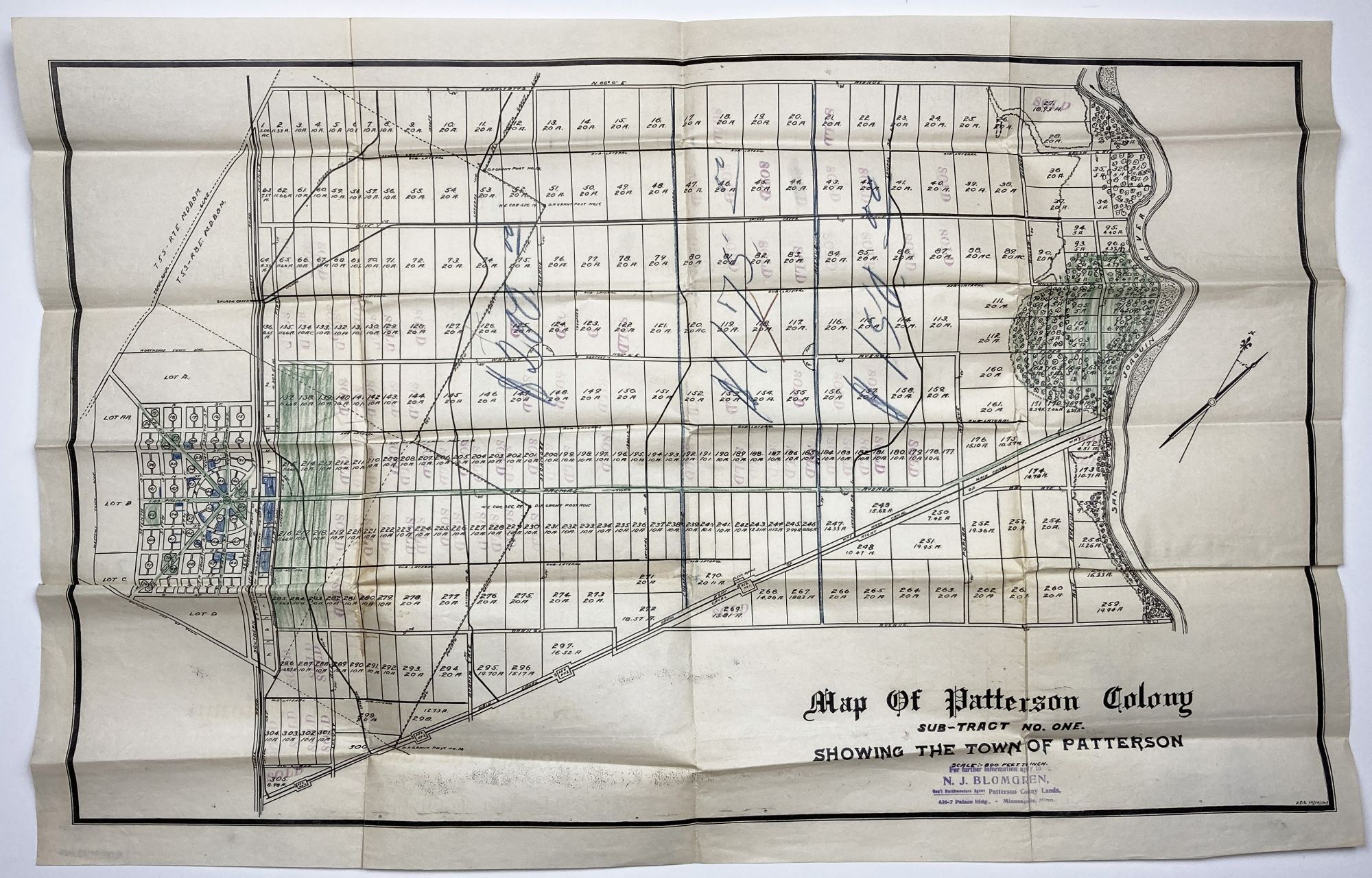
[N.p., perhaps Minneapolis], 1909. Very good.. Lithographed plat map, 19.75 x 30 inches. Folded. Minor wear, numerous plots rubber-stamped "Sold" and with additional shading of some portions in blue or green pencil, and with prices for different groups of lots boldly penciled in, ranging from $150 to $200. Stamp of a Minnesota real estate agent at bottom right. An unrecorded real estate plat map of the central valley town of Patterson, along the San Joaquin River, with the downtown area shown. This particular copy of the map is well used, and contains vital information on the development of the town through sold lots and manuscript additions of pricing information for sections of the town. Below the title is the ink stamp of N.J. Blomgren, Gen'l Northwestern Agent, Patterson Colony Lands, Minneapolis, Minn. Evidently the aim was to get Minnesotans to trade the frigid winters of the Land of Lakes for the scorching summers of the San Joaquin Valley. "J.E.S. 12/5/1909" is printed in lower right corner.
The history of Patterson begins with the Ranch Del Pueblo Mexican Land Grant Land to Mariano and Pedro Hernandez in 1844 by Governor M. Micheltorena. In 1866, John D. Patterson bought 13,340 acres for $5.400 from J. O. Eldredge, who bought the grant from S.G. Reed and R. S. Wade, who had the patent encompassing the land grant signed by President Abraham Lincoln. John D. Patterson purchased additional land, and upon his death in 1902, a total of 18,462 acres were willed to Thomas W. Patterson and William W. Patterson, his estate executors, and other heirs. The land was sold to the Patterson Ranch Company on May 16, 1908 for the sum of $540,000 cash gold coin.
Thomas W. Patterson subdivided the land into ranches of various sizes and plotted the design of the town of Patterson. Determined to make Patterson different from most, he modeled his town after the Cities of Washington D.C. and Paris, France, using a series of circles and radiating streets. Major streets were planted with palms, eucalyptus, and sycamore trees. The Patterson Colony map was filed with the Stanislaus County Recorders office on December 13, 1909. Sales of the ranch properties and city lots commenced. Patterson was the third city in Stanislaus County to incorporate in December 1919. No copies of this map are recorded by OCLC.
Details
Title
Map of Patterson Colony Sub-Tract No. One. Showing the Town of Patterson
Author
[California]
Condition
Very Good
Publisher
[N.p., perhaps Minneapolis]
Date
1909