Washington
by GRAY, Frank A.
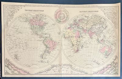
Washington: O.W. Gray & Son. William H. Holmes. Map. Hand colored engraving. Sheet measures 17" x 27 1/4"
Fascinating double hemisphere map surrounded by infographics showing comparative rivers, mountains, and local times. The maps are highly detailed, with countries, regions, major cities, rivers, and topography labeled. In the upper corners, the world's rivers are unfurled and laid out in order of total length, creating a triangular shape that is mirrored on the bottom half of the chart by an arrangement of the world's mountains. Divided by continent and hemisphere, the mountains are arranged from smallest to tallest, with peaks and heights (truncated)
Fascinating double hemisphere map surrounded by infographics showing comparative rivers, mountains, and local times. The maps are highly detailed, with countries, regions, major cities, rivers, and topography labeled. In the upper corners, the world's rivers are unfurled and laid out in order of total length, creating a triangular shape that is mirrored on the bottom half of the chart by an arrangement of the world's mountains. Divided by continent and hemisphere, the mountains are arranged from smallest to tallest, with peaks and heights (truncated)


