Illustrated scroll on paper, entitled on manuscript label on outside of the beginning “Edo yori Bizen Nagasaki made” 江戸より備前長崎迄 [“From Edo to Nagasaki in Bizen Province”]
Scroll (385 x 8560 mm.), with fine colored paintings, using brush, ink, & various colors of wash, of the route and major features along the way. [Japan:] mid-Edo.
The route from Edo (today’s Tokyo) to Nagasaki (and vice versa), by land and by sea, was one of the major thoroughfares and trade routes of Edo-period Japan. The Dutch and Chinese had been allowed to establish exclusive trading outposts in Nagasaki, and Edo was the heart of domestic commerce and administration. Foreign goods, especially silks, other luxury items, raw materials useful to the military, and medicinal goods, flowed through Nagasaki to Edo and the rest of Japan, while Japanese goods, including copper, silver, and porcelain, were transported to Nagasaki for export. Most of the silver was sent to China to settle the trade balance. From the late 1670s to the 1740s, Japan was the world’s largest copper producer and exporter. This route also carried the head of Nagasaki’s Dejima trading post to Edo for frequent mandatory ceremonial audiences with the shogun.
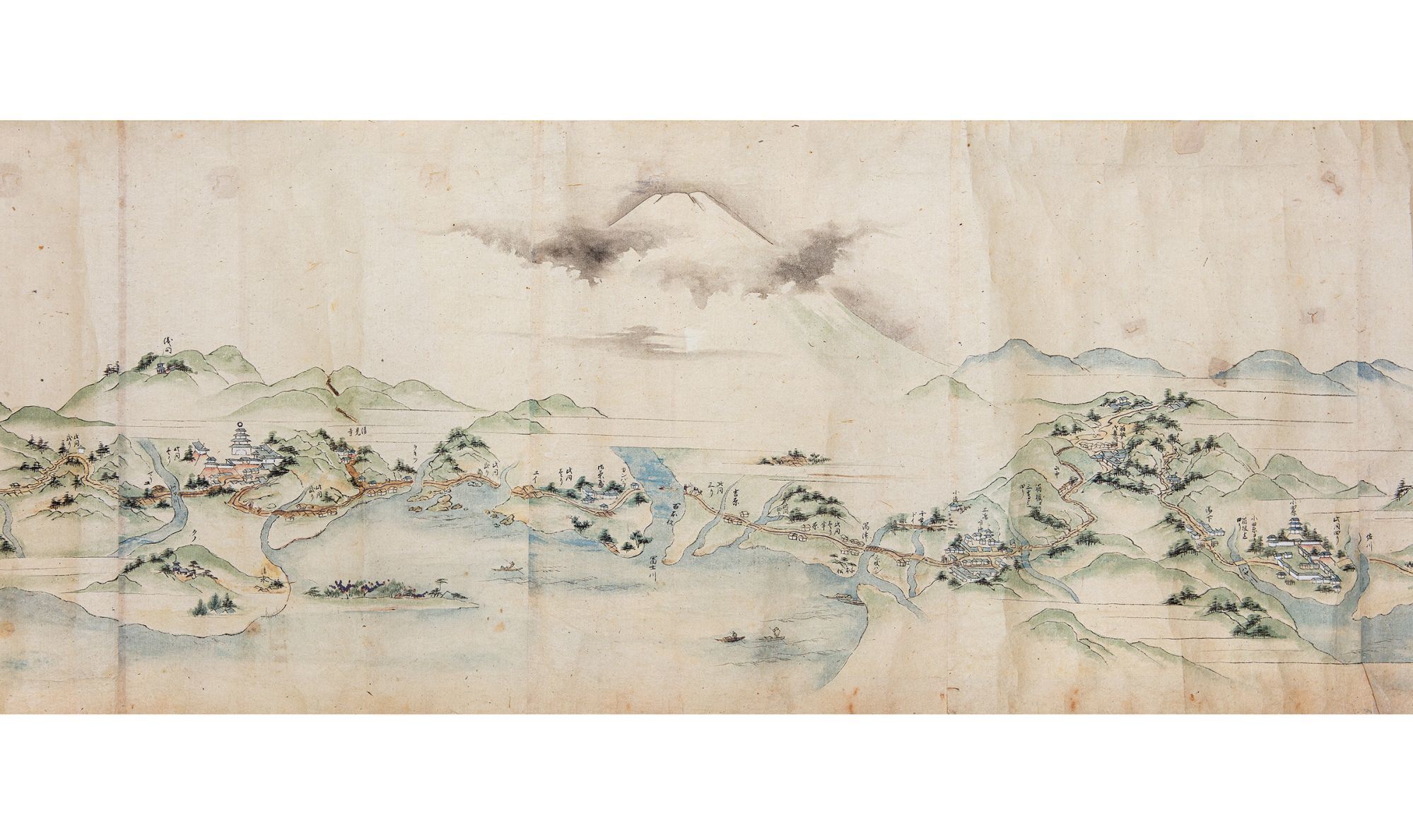
The beginning of our scroll depicts the land route from Edo to Kyoto and then on to Osaka. The famous battleship Atake Maru is seen docked at the mouth of the Sumida River. Starting from Edo Castle in the great capital, the scroll proceeds to Nagoya and Kyoto along the Tōkaidō road, which was the most important highway of the Edo period. It depicts in great detail and with manuscript labels: stations on the route; bridges; major castles, temples, and shrines; the palace at Kyoto; other notable buildings; important geographical features (including Mount Fuji partly shrouded in clouds); and towns and villages along the way.
Distances are given, and travellers are well-depicted, showing their various clothing. Also shown are ships and skiffs in the nearby sea.
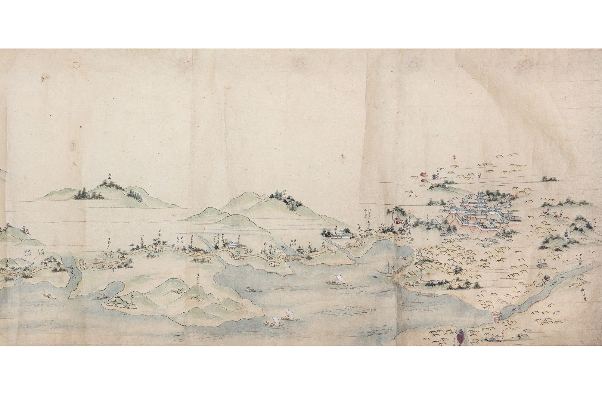
We see more landmarks along the Tōkaidō road from Kyoto to the commercial hub and port city of Osaka, an extension built in the 1620s. Arriving at Osaka, we view the great castle, the city’s canals, and other sites.
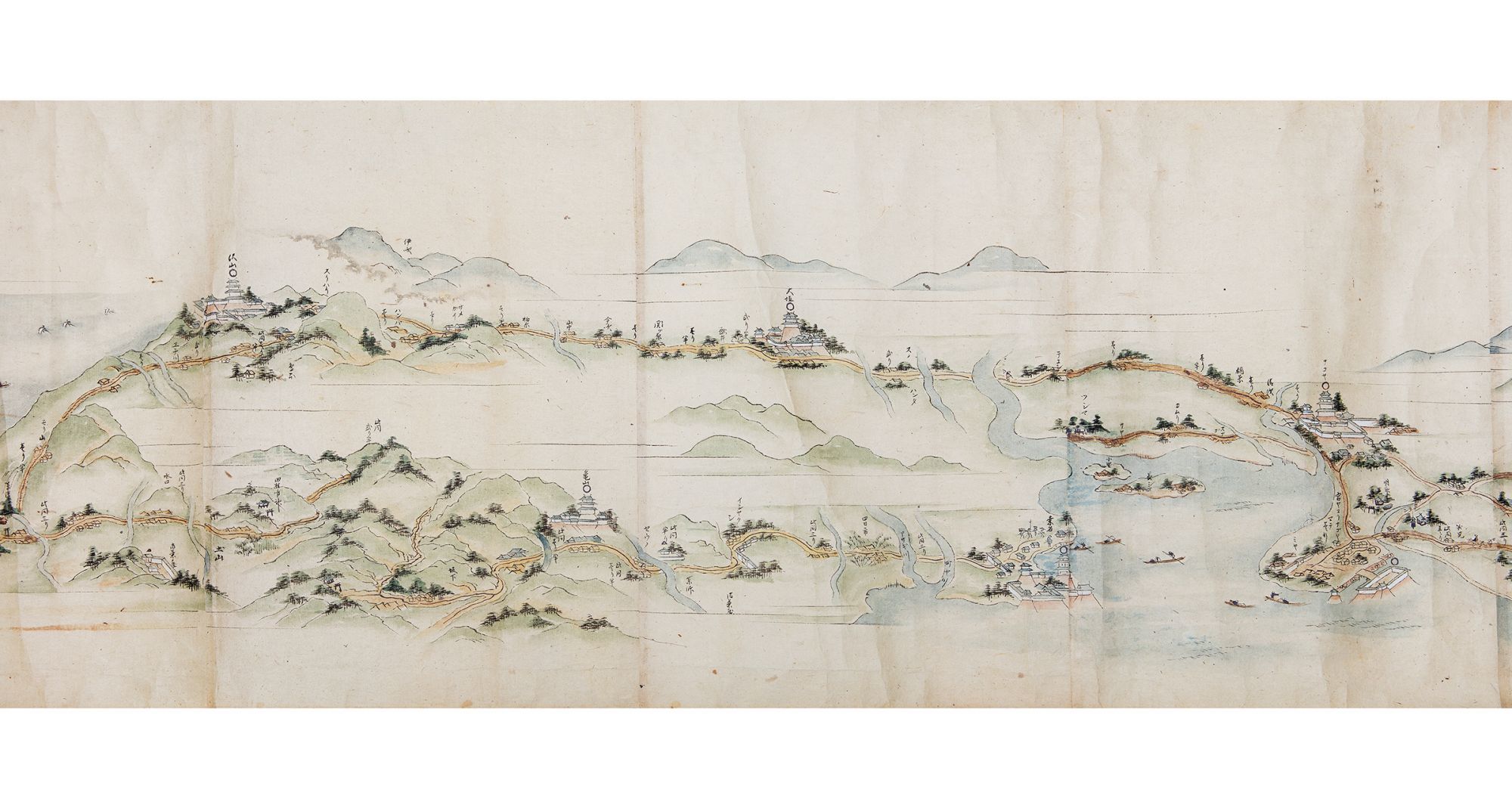
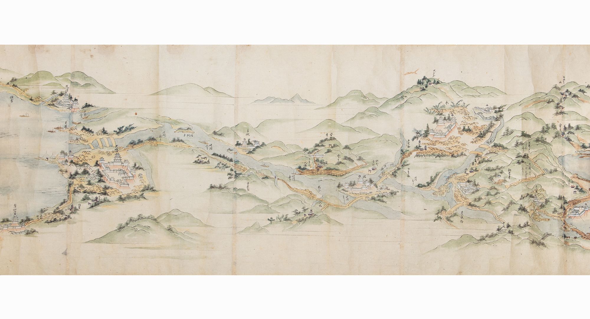
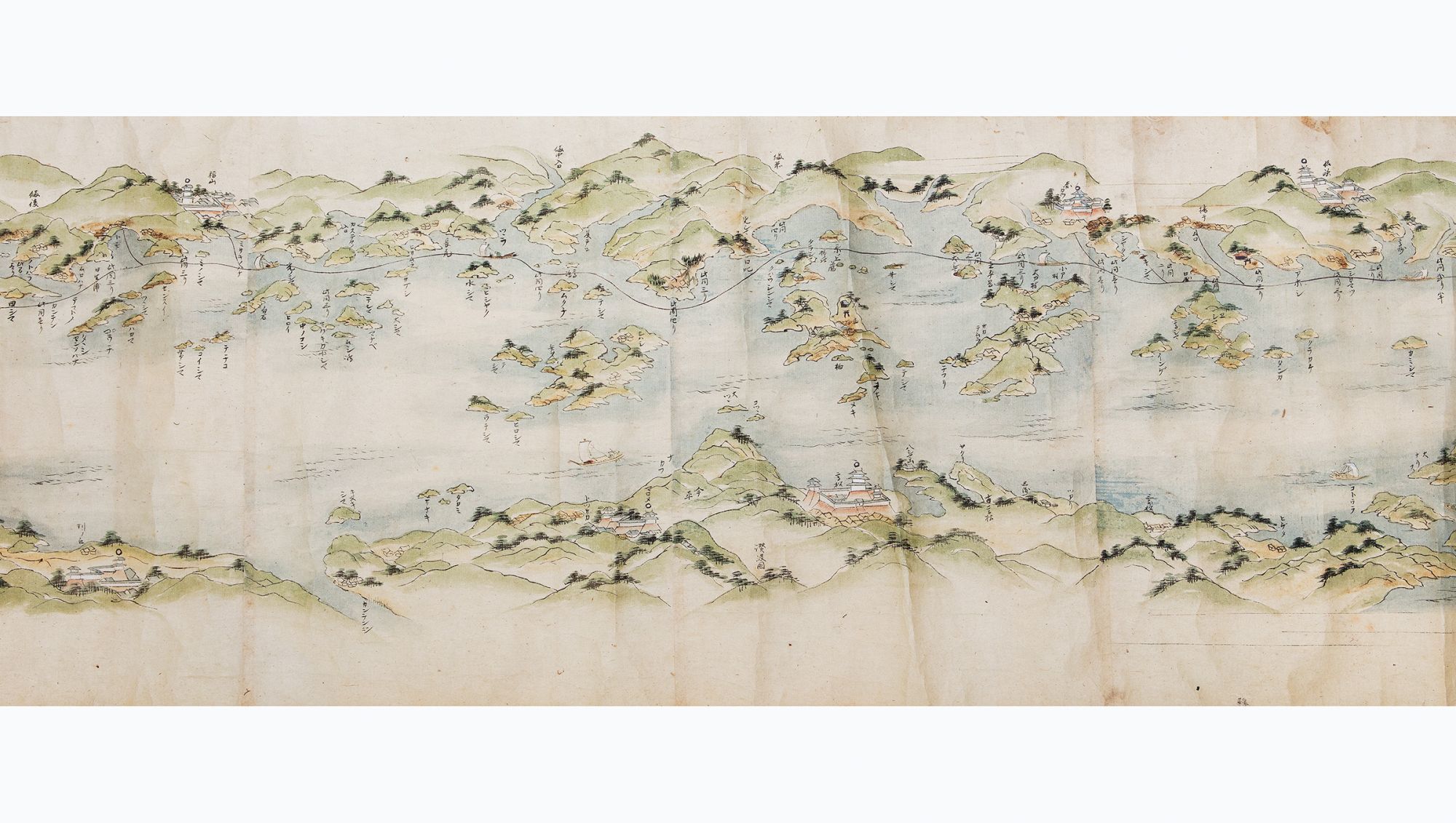
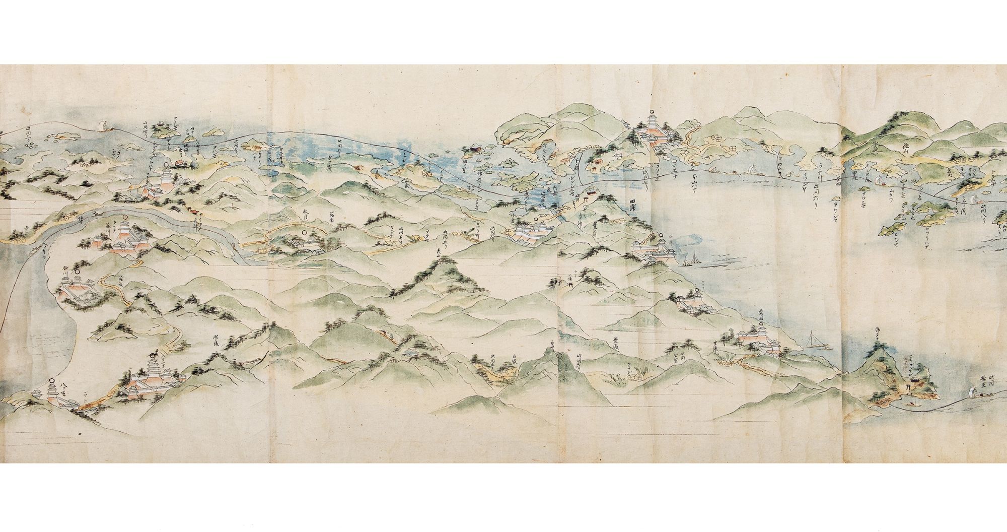
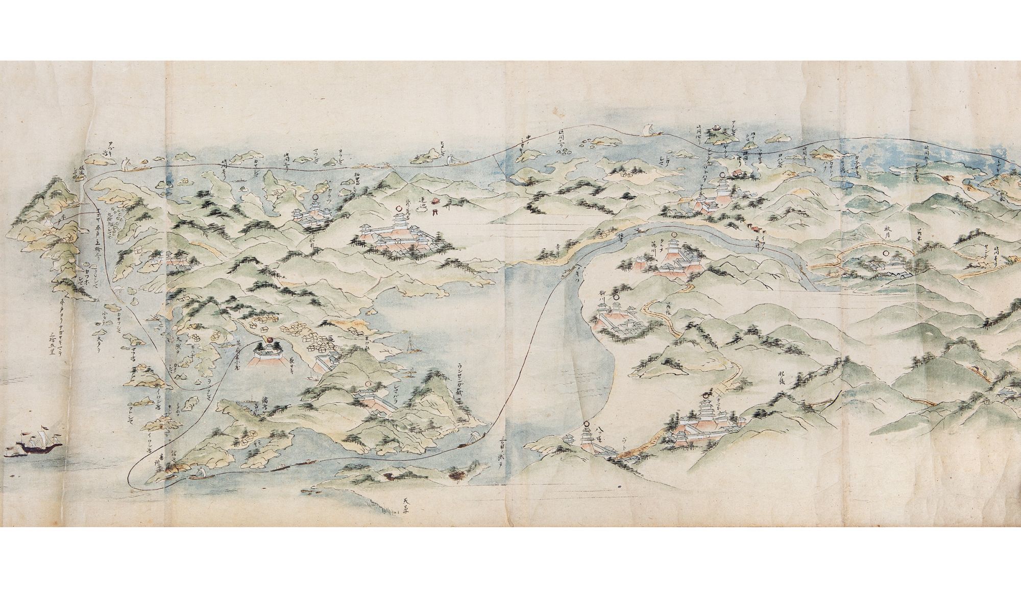
The rest of the scroll shows the hazardous passage from Osaka to Nagasaki through the 400 km. long Inland Sea (Seto Naikai). The accomplished artist depicts the two main routes (and alternate routes depending on the weather), one for summertime in the open sea, and the other, hugging the coast, for wintertime. Another route is shown that involved landing in the Bungo area of Kyūshū island and crossing overland to Nagasaki. Navigating through the Inland Sea, with its 3000 plus islands and rocky outcroppings, presented enormous problems in the era before modern navigation systems. Shown in very great detail are areas of turbulence (including famous whirlpools), numerous islands, rock formations, landscapes for orientation, anchorages, harbors along the way, and fishing areas. The route then passes through the narrow Kanmon Strait, the stretch of water separating the main island of Honshu and Kyūshū, to the Sea of Japan, finally arriving in Nagasaki. Dejima is prominently shown. A foreign ship is shown passing the Gotō islands, making its way to Nagasaki.
Our scroll is finely drawn in black ink and heightened with wash in green, blue, gray, pink, and red. The routes are drawn from a partial “bird’s-eye” perspective, with lovely vistas of mountains and islands and villages and towns.
In fine condition, preserved in an oldish wooden box, which has the inscription on the outside of the lid 江戸長崎海陸道中絵図 [“From Edo to Nagasaki, Travel, by Land and by Sea, Illustrated”]. Inside this lid is the ownership inscription of Ryōra Gakuto.
The route from Edo (today’s Tokyo) to Nagasaki (and vice versa), by land and by sea, was one of the major thoroughfares and trade routes of Edo-period Japan. The Dutch and Chinese had been allowed to establish exclusive trading outposts in Nagasaki, and Edo was the heart of domestic commerce and administration. Foreign goods, especially silks, other luxury items, raw materials useful to the military, and medicinal goods, flowed through Nagasaki to Edo and the rest of Japan, while Japanese goods, including copper, silver, and porcelain, were transported to Nagasaki for export. Most of the silver was sent to China to settle the trade balance. From the late 1670s to the 1740s, Japan was the world’s largest copper producer and exporter. This route also carried the head of Nagasaki’s Dejima trading post to Edo for frequent mandatory ceremonial audiences with the shogun.
The beginning of our scroll depicts the land route from Edo to Kyoto and then on to Osaka. The famous battleship Atake Maru is seen docked at the mouth of the Sumida River. Starting from Edo Castle in the great capital, the scroll proceeds to Nagoya and Kyoto along the Tōkaidō road, which was the most important highway of the Edo period. It depicts in great detail and with manuscript labels: stations on the route; bridges; major castles, temples, and shrines; the palace at Kyoto; other notable buildings; important geographical features (including Mount Fuji partly shrouded in clouds); and towns and villages along the way.
Distances are given, and travellers are well-depicted, showing their various clothing. Also shown are ships and skiffs in the nearby sea.
We see more landmarks along the Tōkaidō road from Kyoto to the commercial hub and port city of Osaka, an extension built in the 1620s. Arriving at Osaka, we view the great castle, the city’s canals, and other sites.
The rest of the scroll shows the hazardous passage from Osaka to Nagasaki through the 400 km. long Inland Sea (Seto Naikai). The accomplished artist depicts the two main routes (and alternate routes depending on the weather), one for summertime in the open sea, and the other, hugging the coast, for wintertime. Another route is shown that involved landing in the Bungo area of Kyūshū island and crossing overland to Nagasaki. Navigating through the Inland Sea, with its 3000 plus islands and rocky outcroppings, presented enormous problems in the era before modern navigation systems. Shown in very great detail are areas of turbulence (including famous whirlpools), numerous islands, rock formations, landscapes for orientation, anchorages, harbors along the way, and fishing areas. The route then passes through the narrow Kanmon Strait, the stretch of water separating the main island of Honshu and Kyūshū, to the Sea of Japan, finally arriving in Nagasaki. Dejima is prominently shown. A foreign ship is shown passing the Gotō islands, making its way to Nagasaki.
Our scroll is finely drawn in black ink and heightened with wash in green, blue, gray, pink, and red. The routes are drawn from a partial “bird’s-eye” perspective, with lovely vistas of mountains and islands and villages and towns.
In fine condition, preserved in an oldish wooden box, which has the inscription on the outside of the lid 江戸長崎海陸道中絵図 [“From Edo to Nagasaki, Travel, by Land and by Sea, Illustrated”]. Inside this lid is the ownership inscription of Ryōra Gakuto.
Details
Title
Illustrated scroll on paper, entitled on manuscript label on outside of the beginning “Edo yori Bizen Nagasaki made” 江戸より備前長崎迄 [“From Edo to Nagasaki in Bizen Province”]
Author
EDO TO NAGASAKI TRADE ROUTES
Condition
Unknown