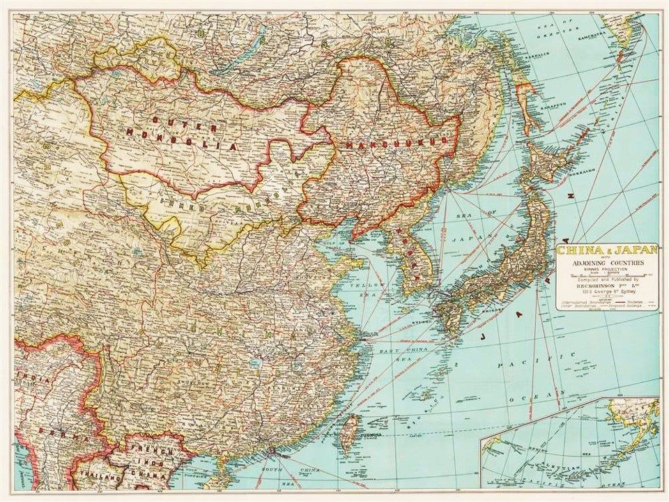
China and Japan Mapped with Adjoining Countries [Manchukuo / Far East Strategic Map] [ca. 1937-1940]

- Sydney: H.E.C. Robinson Pty. Ltd., 1940
Sydney: H.E.C. Robinson Pty. Ltd., 1940. Very Good.
An uncommon and strategically vital folding map of East Asia, documenting the complex territorial disputes of the Second Sino-Japanese War.
This edition, compiled by the premier Sydney cartographic house of H.E.C. Robinson, offers a detailed view of the international and provincial boundaries of China, Japan, and their neighbors during the height of the Japanese occupation.
The map is a 'Copy 1' variant, distinguished by its bold identification of 'Manchukuo' across northeast China and an unshaded title cartouche. Beyond its political boundaries, the work serves as a detailed guide to regional transportation, featuring shipping routes, major roads, and the critical rail networks-including the Trans-Siberian line-that defined the logistics of the era. An essential primary document for the study of 20th-century Asian geopolitics and the cartographic history of the Pacific War.
KEY FEATURES
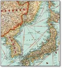
+++ Visuals: Full-color map using Bonnes Projection; features a large-scale view of East Asia (1:6,000,000) with relief shown by shading.
+++ Inset: Includes a detailed map of the Aleutian Islands and the Bering Sea at 1:12,000,000 scale.
+++ Binding: Original pictorial card wraps, likely published with a tropical or regional motif consistent with Robinson's other pre-war folding maps.
+++ Content: Documents international and provincial boundaries, populated places, and extensive transportation networks.
+++ Imprint: H.E.C. Robinson Pty. Ltd., Sydney. No printed date; dated by content to the 1937-1940 window.
+++ Specs: Approximately 27.5 x 37.5 inches (70 x 95 cm) when unfolded.
CONDITION: Very Good.
+++ The Map: The color remains bright and vibrant throughout. The paper is crisp, showing only the expected wear at the original folding points. Internally clean with no significant markings or loss to the cartographic surface.
+++ The Wraps: The pictorial covers show light shelf handling and minor age-toning typical for paper ephemera of this period.
SCHOLARLY FEATURES
+++ Political Cartography: Captures the 'cartographic reality' of the Japanese occupation, marking the puppet state of Manchukuo as a distinct entity-a status not recognized by many contemporary nations.
+++ Strategic Logistics: Provides a snapshot of the shipping and rail infrastructure that supported both civilian trade and military movement in the Far East during the late 1930s.
+++ Regional Scarcity: While variants are held by the National Library of Australia, this specific map is uncommon in the trade, especially in its original folding state.
+++ Infrastructure & Logistics: Meticulously details the Trans-Siberian Railway and regional shipping lanes, highlighting the vital supply lines of the era. HISTORICAL SIGNIFICANCE -
H.E.C. Robinson established himself as the definitive mapmaker for Australia and the South Pacific, with his firm providing the geographical context for the 'Near North' to an anxious public. This map, released between 1937 and 1940, captures the final years of the pre-Pearl Harbor era, when the Second Sino-Japanese War was the primary concern of Pacific observers. The bold naming of 'Manchukuo' and 'Manchuria' across different variants reflects the evolving-and often conflicting-political labels of the period.
SUBJECTS: East Asia History, Second Sino-Japanese War, Manchukuo, Cartography of Japan, Chinese Provincial Boundaries, Australian Printing. Map, Ephemera, 20th-century Cartography.
BIBLIOGRAPHIC REFERENCE: Trove #1858554; NLA Bib ID 1528434.
An uncommon and strategically vital folding map of East Asia, documenting the complex territorial disputes of the Second Sino-Japanese War.
This edition, compiled by the premier Sydney cartographic house of H.E.C. Robinson, offers a detailed view of the international and provincial boundaries of China, Japan, and their neighbors during the height of the Japanese occupation.
The map is a 'Copy 1' variant, distinguished by its bold identification of 'Manchukuo' across northeast China and an unshaded title cartouche. Beyond its political boundaries, the work serves as a detailed guide to regional transportation, featuring shipping routes, major roads, and the critical rail networks-including the Trans-Siberian line-that defined the logistics of the era. An essential primary document for the study of 20th-century Asian geopolitics and the cartographic history of the Pacific War.
KEY FEATURES
+++ Visuals: Full-color map using Bonnes Projection; features a large-scale view of East Asia (1:6,000,000) with relief shown by shading.
+++ Inset: Includes a detailed map of the Aleutian Islands and the Bering Sea at 1:12,000,000 scale.
+++ Binding: Original pictorial card wraps, likely published with a tropical or regional motif consistent with Robinson's other pre-war folding maps.
+++ Content: Documents international and provincial boundaries, populated places, and extensive transportation networks.
+++ Imprint: H.E.C. Robinson Pty. Ltd., Sydney. No printed date; dated by content to the 1937-1940 window.
+++ Specs: Approximately 27.5 x 37.5 inches (70 x 95 cm) when unfolded.
CONDITION: Very Good.
+++ The Map: The color remains bright and vibrant throughout. The paper is crisp, showing only the expected wear at the original folding points. Internally clean with no significant markings or loss to the cartographic surface.
+++ The Wraps: The pictorial covers show light shelf handling and minor age-toning typical for paper ephemera of this period.
SCHOLARLY FEATURES
+++ Political Cartography: Captures the 'cartographic reality' of the Japanese occupation, marking the puppet state of Manchukuo as a distinct entity-a status not recognized by many contemporary nations.
+++ Strategic Logistics: Provides a snapshot of the shipping and rail infrastructure that supported both civilian trade and military movement in the Far East during the late 1930s.
+++ Regional Scarcity: While variants are held by the National Library of Australia, this specific map is uncommon in the trade, especially in its original folding state.
+++ Infrastructure & Logistics: Meticulously details the Trans-Siberian Railway and regional shipping lanes, highlighting the vital supply lines of the era. HISTORICAL SIGNIFICANCE -
H.E.C. Robinson established himself as the definitive mapmaker for Australia and the South Pacific, with his firm providing the geographical context for the 'Near North' to an anxious public. This map, released between 1937 and 1940, captures the final years of the pre-Pearl Harbor era, when the Second Sino-Japanese War was the primary concern of Pacific observers. The bold naming of 'Manchukuo' and 'Manchuria' across different variants reflects the evolving-and often conflicting-political labels of the period.
SUBJECTS: East Asia History, Second Sino-Japanese War, Manchukuo, Cartography of Japan, Chinese Provincial Boundaries, Australian Printing. Map, Ephemera, 20th-century Cartography.
BIBLIOGRAPHIC REFERENCE: Trove #1858554; NLA Bib ID 1528434.
Details
Title
China and Japan Mapped with Adjoining Countries [Manchukuo / Far East Strategic Map] [ca. 1937-1940]
Author
[Robinson, H.E.C.]
Condition
Very Good
Publisher
H.E.C. Robinson Pty. Ltd.: Sydney
Date
1940