Barbados, Surveyed By William Mayo
- London: Printed for Robert Sayer, 1775
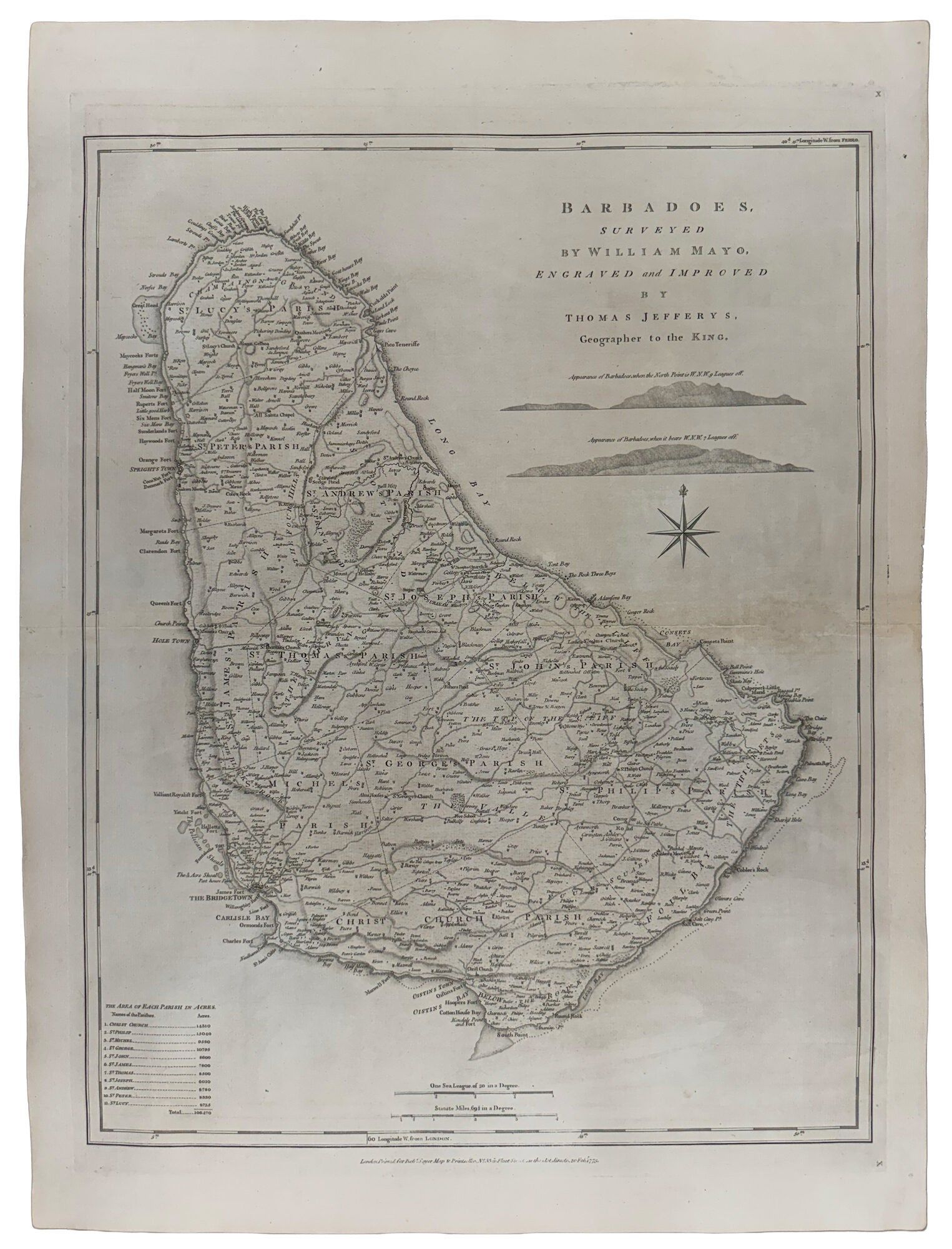
London: Printed for Robert Sayer, 1775. Engraved map, uncoloured, with two engraved coastal profile views, compass rose, scale bars in sea leagues and statute miles, graduated border, and a table of the acreages of the eleven parishes. A richly detailed Barbados map after William Mayo's authoritative survey, combining plantation geography, colonial administration, and maritime intelligence at the height of Britain's Caribbean sugar economy.
The map is rich in the practical detail of an eighteenth-century plantation island. The eleven parishes are named in large engraved capitals, with their boundaries clearly delineated: St. Lucy, St. Peter, St. Andrew, St. James, St. Thomas, St. Joseph, St. John, St. George, St. Michael, Christ Church, and St. Philip. The table at lower left gives the "Area of Each Parish in Acres," totaling 106,470 acres, a figure also given by Schomburgk in his nineteenth-century history of Barbados. Roads thread across the interior, linking churches, chapels, estates, mills, and settlements. The density of estate and family names makes the map valuable as a document of landholding, plantation geography, and local administration. The coastal detail is equally important. Bridgetown is prominently named at the southwest, with James Fort, Carlisle Bay, Willoughby Bay, Ormonds Fort, Charles Fort, Needhams Point, and the Freshwater Shoal. Along the west and northwest coast the map marks Hole Town, Church Point, Maycocks Forts, Half Moon Fort, Six Mens Fort, North Point, Cave Bay, and Pico Teneriffe. The windward coast includes Tent Bay, The Rock Three Boys, Adderleys Bay, Consets Bay, Congets Point, Bull Point, Culpeppers Little Island, The Chair, Kitridge Bay, Cave Bay, Long Bay, and Salt Cave Point. These names, together with the dotted reefs and shoals, give the map the character of both a civil survey and a navigational chart. The two engraved profile views beneath the title, each labelled "Appearance of Barbadoes," show the island as it would be recognised from offshore. Their inclusion, along with the compass rose and dual scale bars, reflects the practical maritime use of Jefferys' Caribbean mapping. Barbados stood to windward of the Lesser Antilles and was a crucial first landfall and naval station for British Atlantic navigation. The map therefore served several functions at once: geographical description, colonial administration, plantation record, and sea approach guide. Mayo's original survey was commissioned in 1717. Mayo identified approximately 986 plantations, using windmill symbols to indicate sugar-processing capacity. Schomburgk further notes that the Barbados legislature commissioned Mayo to make a map of the island and fix the parish lines. Jefferys' later version thus preserves, in a more compact and commercially accessible form, one of the central cartographic records of eighteenth-century Barbados. Thomas Jefferys was one of the leading English cartographers of the 18th century. From about 1750, he published a series of maps of the Americas, that were among the most significant produced in the period. As Geographer to the Prince of Wales, and after 1761, Geographer to the King, Jefferys was well-placed to have access to the best surveys conducted, and many of his maps held the status of "official work." Jefferys died on 20th November 1771, but Robert Sayer (in partnership with John Bennett) 'having acquired the sole property of the Plates' and other material relating to the work, 'minutely followed' Jefferys' plans for The West India Atlas although Sayer does note that additional work was done using various sources to ensure that the information was up to date.
See also: D. Gestetner "Thomas Jefferys': West-India Atlas, 1775" in MapForum, issue 7 (2005), pp.40-48 & issue 8 (2005), pp.30-35; Phillips 2699.
Details
Title
Barbados, Surveyed By William Mayo
Author
JEFFERYS, Thomas (1719-1771)
Condition
Unknown
Publisher
Printed for Robert Sayer: London
Date
1775