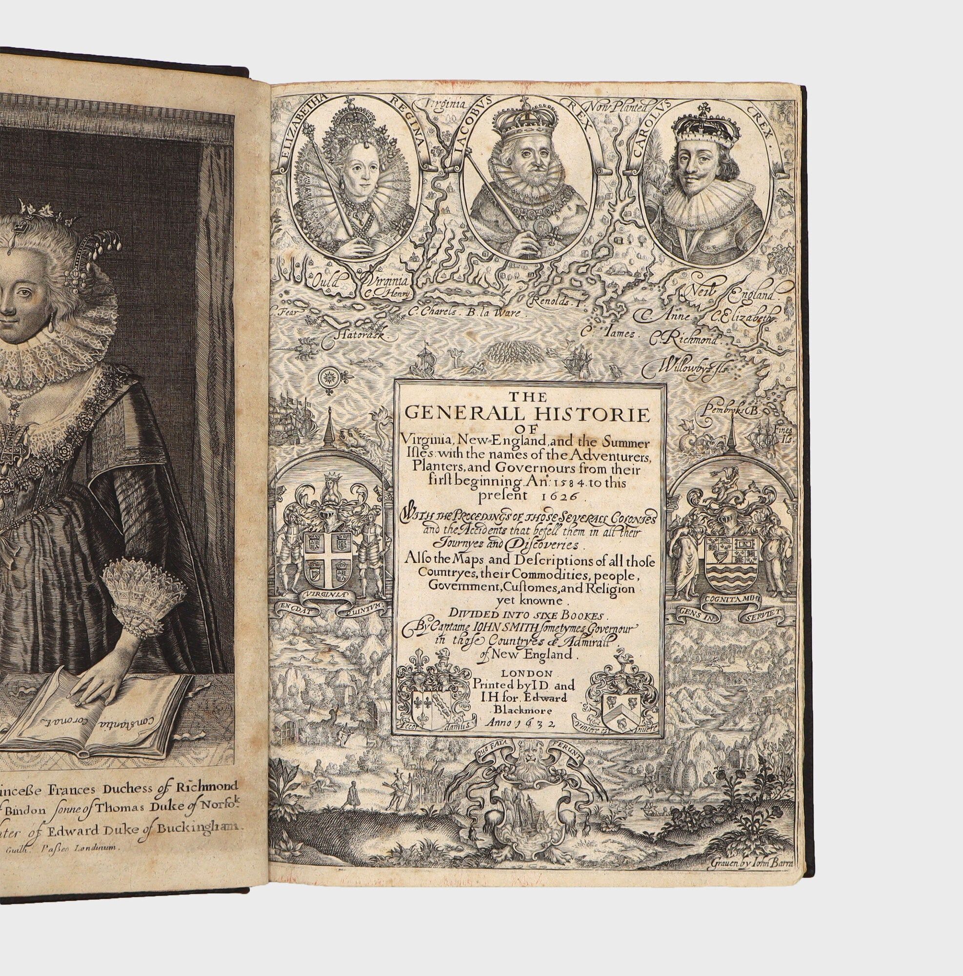
The Generall Historie of Virginia, New-England, and the Summer Isles: with the names of the Adventurers, Planters, and Governours from their first beginning An°: 1584 to this present 1626

- Engraved title and four folding engraved maps. [12], 1-96, 105-248pp. Extra-illustrated with an engraved portrait of the Duchess
- London: Printed by I.D. and I.H. for Edward Blackmore, 1632
London: Printed by I.D. and I.H. for Edward Blackmore, 1632. First edition, sixth and final state of the title. Engraved title and four folding engraved maps. [12], 1-96, 105-248pp. Extra-illustrated with an engraved portrait of the Duchess of Richmond and Lenox. Folio. Period style binding using old calf, covers panelled in gilt, spine gilt with red morocco label, rear pastedown renewed. Minor repaired tears at gutters of folding maps, the engraved portrait expertly remargined at the larger margin below the imprint. Provenance: John Tremen (?) (signature on front endpaper, partially crossed out, dated February 20, 1653); Philadelphia Tremen (?) (later signature on front endpaper). Housed in a morocco backed box. First edition, sixth and final state of the title. Engraved title and four folding engraved maps. [12], 1-96, 105-248pp. Extra-illustrated with an engraved portrait of the Duchess of Richmond and Lenox. Folio. Smith's Virginia is arguably the most important single work on the early English colonization of North America. Captain John Smith (1580-1631) was involved in the Jamestown colony in Virginia from its beginning in 1607, and his exploits during the difficult early days of the settlement, especially his dealings with the Indians of the area, are the stuff of American legend. Besides his swashbuckling persona as a man of action, Smith was a careful observer and persistent and inquiring explorer. His activities included not only Virginia and the Chesapeake, but the exploration of the New England coast as well. Both the book and its maps are of the greatest possible importance for early American history.
Smith played a key role in the founding of the new settlement of Jamestown and all of his books and pamphlets were designed to encourage trade and colonization overseas. But his "masterpiece is the Generall Historie, which was the first sizeable work written in English about the newfound continent" (PMM 124). Following a survey of voyages to America to 1605, Smith describes the physical features, natural products, and Native Americans on Chesapeake Bay. His historical account of the Virginia Colony covers the period from 1606 to 1624 and includes much knowledge acquired at first hand.
The Generall Historie and its maps appear in a complex variety of issues. The text of the work was printed by two printers, to each of whom Smith gave half the text. Their miscalculation of text length created a break in pagination, as issued (there are no pp. 97-104). Although there is only one printing of the text, Smith continually updated the titlepage of the work to keep it current and to reflect the death of James I and the accession of Charles I, whose portraits appear on the title. The first issue titlepage is dated 1624, the date of the printing of the text. Subsequent titles are dated 1625, 1626, 1627, 1631, and 1632 (as here). At the same time as new titles were issued, Smith continually altered the copper plates of the four maps, adding place names or changing details. According to the bibliographer Wilberforce Eames, the foremost authority on the book, only certain issues of each map are properly found with each title issue. The work, however, is often found with the incorrect states of the maps or the title supplied at later date. All the maps and plates present here are the correct states for the 1632 second issue of the title.
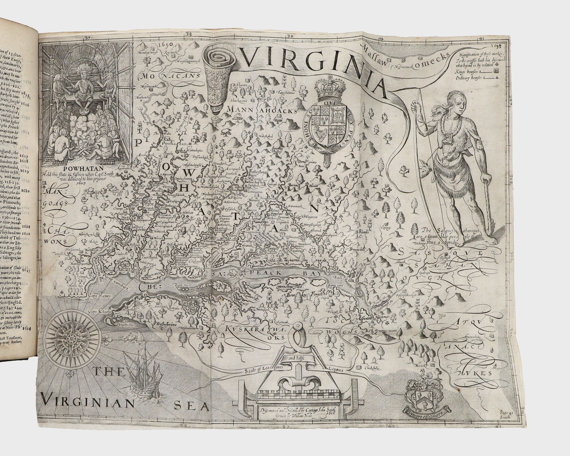
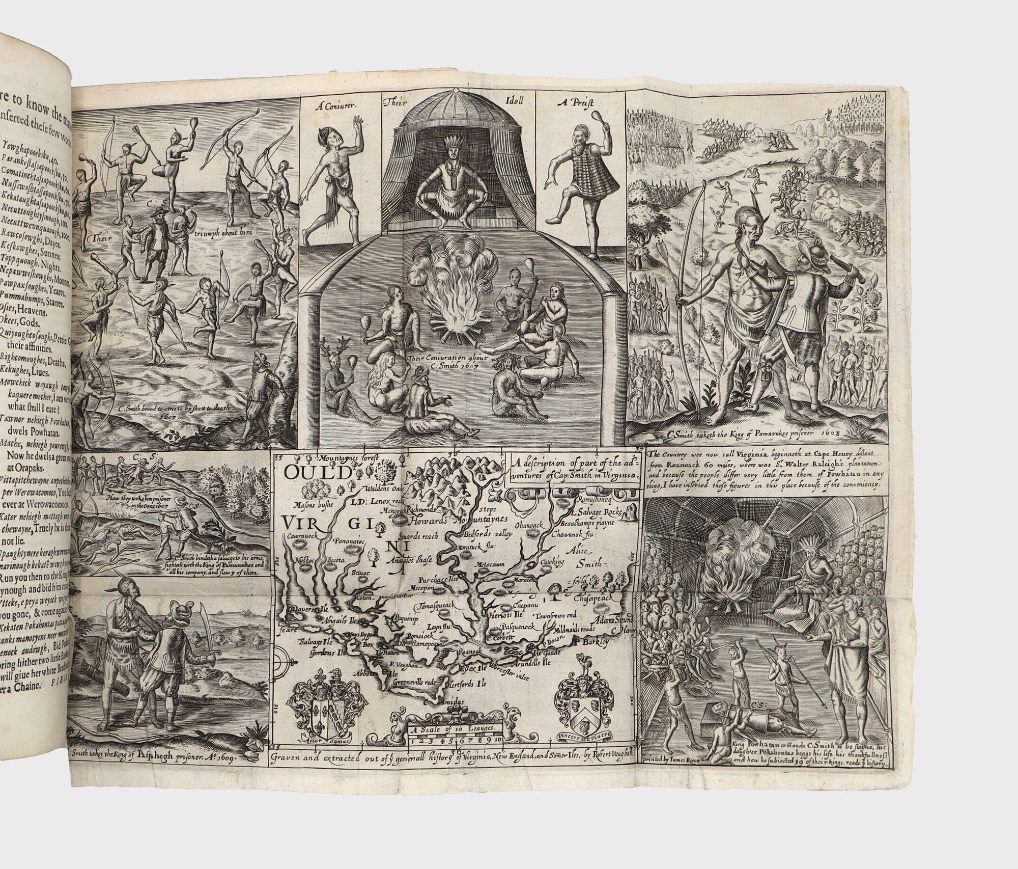
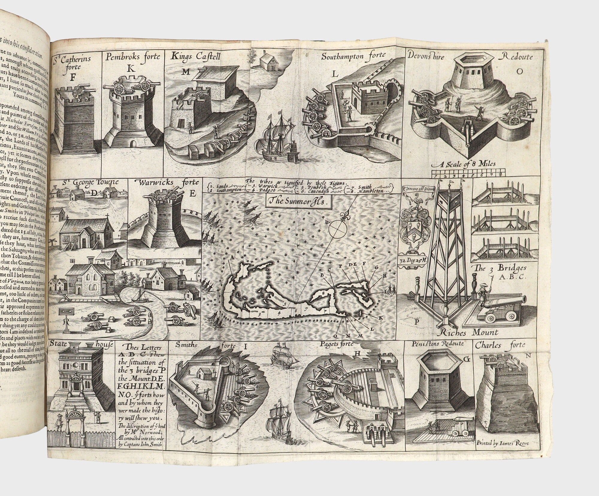
The first map, the map of Virginia, shows the present states of Virginia and Maryland and the Chesapeake Bay. It is one of the most important cartographical works related to North America in the 17th century. There are twelve known states of the map, and it is present here in the eleventh state. The second map, Ould Virginia, has a small cartographical panel showing the Carolina Capes where the abortive Roanoake settlement had been. It is more famous for the engraved scenes of Smith's adventures in Virginia which surround it, especially the famous depiction of Pocahontas saving Smith from execution. It appears in four states, of which this is the fourth. The third map, that of New England, has been rightly called "the foundation map of New England cartography." (Burden). Smith had first published this map in 1616, and it went through nine states in all, of which the ninth is present here. The fourth map, of Bermuda, also occupies a founding position in the detailed cartography of the islands. There are three states, of which the third is present here.
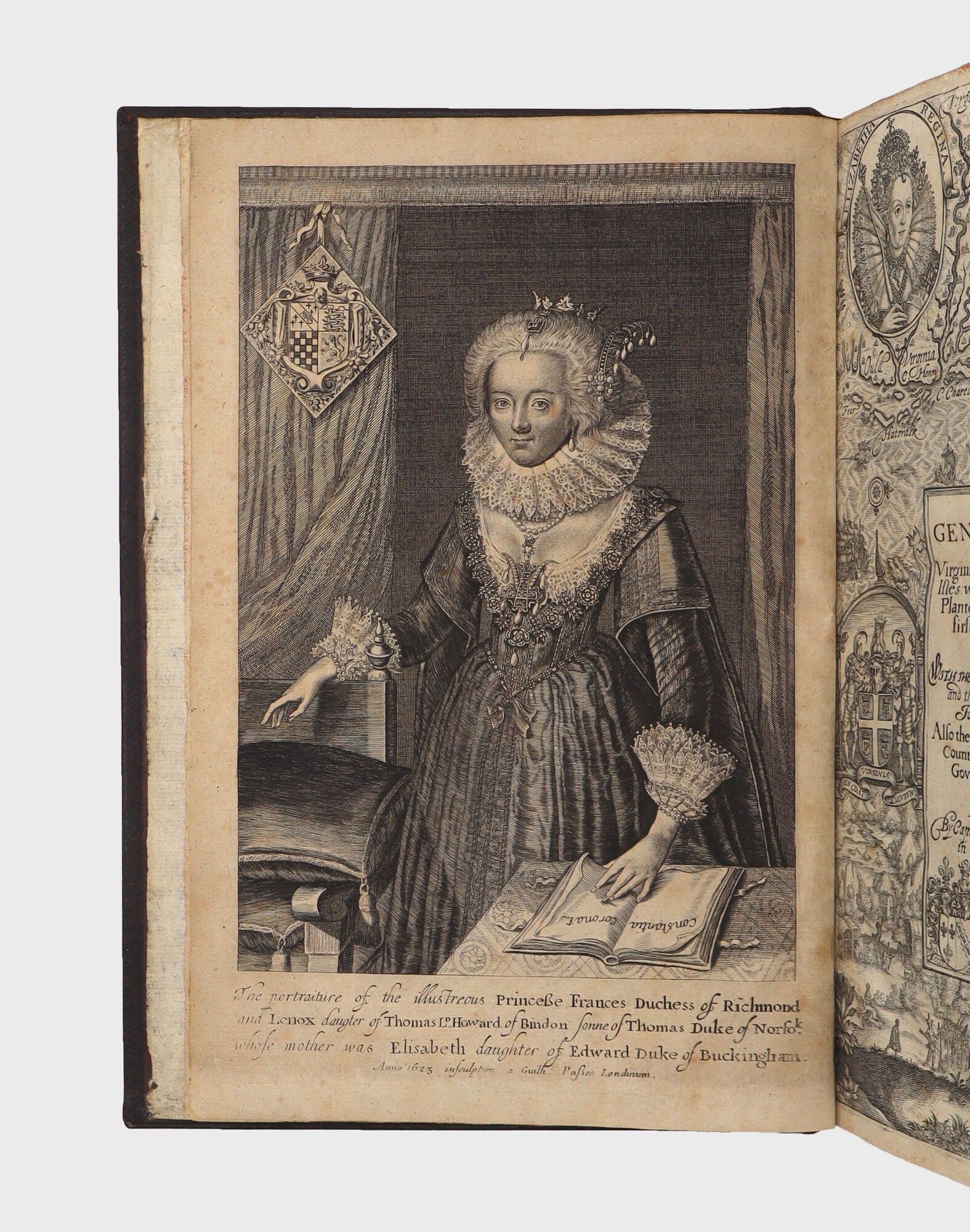
Two portraits are sometimes found bound into copies of the Generall Historie, though were not included in all copies and were likely separately issued and inserted: the Duchess of Richmond and Lenox, to whom the book was dedicated, and Pocahontas. The Duches of Richmond portrait is present here, being a re-engraved edition done circa 1796. See Eames's note in the lengthy entry on Smith in Sabin.
"Recounting his exploits among Virginia's Algonquians, Smith boldly created his own personal history. He reinforced the words of his story with illustrations derived from de Bry, into which he inserted himself. Since the pictures were intended less to inform his readers about Algonquian life than to make his own story dramatic and believable, Smith may have used de Bry's images because his readers would have been comfortably familiar with them. They had become symbols of America that could be manipulated independently of the reality that they purported to represent. At the same time, the 'Indians' they depicted became increasingly abstract concepts whose meaning for European readers lay not in their specific culture but in their role as foils for European adventurers" (Creating America)
A foundational work. ESTC S111886; European Americana 632/99; Sabin 82829; Church 422; JCB (3)II:245; Miles & Reese, America Pictured to Life 27; PMM 124. For the maps see Burden North America 164, 187, 212, 213 and Verner, "Smith's Virginia and its Derivatives" in The Mapping of America, pp. 136-160. See Sabin, XX, pp. 225-245 for a detailed discussion by Wilberforce Eames, especially the issues of the maps, the portraits, and the titlepages
Smith played a key role in the founding of the new settlement of Jamestown and all of his books and pamphlets were designed to encourage trade and colonization overseas. But his "masterpiece is the Generall Historie, which was the first sizeable work written in English about the newfound continent" (PMM 124). Following a survey of voyages to America to 1605, Smith describes the physical features, natural products, and Native Americans on Chesapeake Bay. His historical account of the Virginia Colony covers the period from 1606 to 1624 and includes much knowledge acquired at first hand.
The Generall Historie and its maps appear in a complex variety of issues. The text of the work was printed by two printers, to each of whom Smith gave half the text. Their miscalculation of text length created a break in pagination, as issued (there are no pp. 97-104). Although there is only one printing of the text, Smith continually updated the titlepage of the work to keep it current and to reflect the death of James I and the accession of Charles I, whose portraits appear on the title. The first issue titlepage is dated 1624, the date of the printing of the text. Subsequent titles are dated 1625, 1626, 1627, 1631, and 1632 (as here). At the same time as new titles were issued, Smith continually altered the copper plates of the four maps, adding place names or changing details. According to the bibliographer Wilberforce Eames, the foremost authority on the book, only certain issues of each map are properly found with each title issue. The work, however, is often found with the incorrect states of the maps or the title supplied at later date. All the maps and plates present here are the correct states for the 1632 second issue of the title.
The first map, the map of Virginia, shows the present states of Virginia and Maryland and the Chesapeake Bay. It is one of the most important cartographical works related to North America in the 17th century. There are twelve known states of the map, and it is present here in the eleventh state. The second map, Ould Virginia, has a small cartographical panel showing the Carolina Capes where the abortive Roanoake settlement had been. It is more famous for the engraved scenes of Smith's adventures in Virginia which surround it, especially the famous depiction of Pocahontas saving Smith from execution. It appears in four states, of which this is the fourth. The third map, that of New England, has been rightly called "the foundation map of New England cartography." (Burden). Smith had first published this map in 1616, and it went through nine states in all, of which the ninth is present here. The fourth map, of Bermuda, also occupies a founding position in the detailed cartography of the islands. There are three states, of which the third is present here.
Two portraits are sometimes found bound into copies of the Generall Historie, though were not included in all copies and were likely separately issued and inserted: the Duchess of Richmond and Lenox, to whom the book was dedicated, and Pocahontas. The Duches of Richmond portrait is present here, being a re-engraved edition done circa 1796. See Eames's note in the lengthy entry on Smith in Sabin.
"Recounting his exploits among Virginia's Algonquians, Smith boldly created his own personal history. He reinforced the words of his story with illustrations derived from de Bry, into which he inserted himself. Since the pictures were intended less to inform his readers about Algonquian life than to make his own story dramatic and believable, Smith may have used de Bry's images because his readers would have been comfortably familiar with them. They had become symbols of America that could be manipulated independently of the reality that they purported to represent. At the same time, the 'Indians' they depicted became increasingly abstract concepts whose meaning for European readers lay not in their specific culture but in their role as foils for European adventurers" (Creating America)
A foundational work. ESTC S111886; European Americana 632/99; Sabin 82829; Church 422; JCB (3)II:245; Miles & Reese, America Pictured to Life 27; PMM 124. For the maps see Burden North America 164, 187, 212, 213 and Verner, "Smith's Virginia and its Derivatives" in The Mapping of America, pp. 136-160. See Sabin, XX, pp. 225-245 for a detailed discussion by Wilberforce Eames, especially the issues of the maps, the portraits, and the titlepages
Details
Title
The Generall Historie of Virginia, New-England, and the Summer Isles: with the names of the Adventurers, Planters, and Governours from their first beginning An°: 1584 to this present 1626
Author
Smith, Capt. John
Binding
Engraved title and four folding engraved maps. [12], 1-96, 105-248pp. Extra-illustrated with an engraved portrait of the Duchess
Condition
Unknown
Publisher
Printed by I.D. and I.H. for Edward Blackmore: London
Date
1632
Edition
First edition, sixth and final state of the title