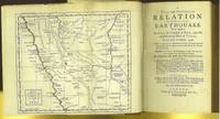
A true and particular relation of the dreadful earthquake wich happen'd at Lima, the Capital of Peru, and the neighbouring Port of Callao, on the 28th of October, 1746. With an account likewise of every thing material that passed there afterwards to the end of november following. Published at Lima by Command of the Viceroy, and translated from the original Spanish ... To which is added, a description of Callao and Lima before the destruction ; and of the kingdom of Peru in general
- Hardcover
- London: Printed for T Osborn, 1748
xxiii[1]+341+[3 ad] pages with frontispiece foldout map, 3 folding copper engraved plans, 5 folding copper engraved plates. Octavo (8 1/4" x 5 1/2") rebound in buckram and tanned leather, spine with raised bands, title and author in gilt on spine. Translation byo Henry Johnson. [Cox II:p.272, not having seen the first edition; Sabin 42593] 2d edition printed the same year as the first.
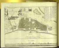
The subject of this title is the most deadly earthquake in Peru's history prior to 1970, the so-called Great Earthquake of 1746 which caused massive destruction, killing thousands of people. Callao, a sea-port town, two leagues south from Lima was, of course, also hit. Just as the people of Callao were starting to come to their senses, a giant Tsunami hit the port. Callao was swallowed up by the sea and basically vanished. A British sailing vessel in the port was washed two miles inland. The folding map shows the country around Lima, with Callao just to the south, a plan of the road from Lima to Callao, a plan of the town of Callao (as it was before the earthquake), a plan of the city of Lima, and several plates of the natives. Included is an historical account of Callao and Lima, and of Peru in general with information on the people, their manners, customs, religion, government, commerce, etc. Appended is an account of the earthquake in Jamaica in 1692. The folding maps are as follows: the country around Lima, with Callao just to the south; a plan of the road from Lima to Callao; a plan of the town of Callao (as it was prior to the quake); a plan of the city of Lima; and several plates of the natives. Included is an historical account of Callao and Lima, and of Peru in general with information on the people, their manners, customs, religion, government, commerce, etc. Appended is an account of the great and deastating earthquake in Jamaica in 1692 which also wiped Port Royal off the map.
Condition: "Antiquarian Society of Worcester" embossed imprint on title else a very good to fine copy..
Details
Title
A true and particular relation of the dreadful earthquake wich happen'd at Lima, the Capital of Peru, and the neighbouring Port of Callao, on the 28th of October, 1746. With an account likewise of every thing material that passed there afterwards to the end of november following. Published at Lima by Command of the Viceroy, and translated from the original Spanish ... To which is added, a description of Callao and Lima before the destruction ; and of the kingdom of Peru in general
Author
Pedro Lozano (1697-1752)
Binding
Hardcover
Condition
Very Good
Publisher
Printed for T Osborn: London
Date
1748
Edition
Second Edition
Size
Octavo
Pages
xxiii[1]+341+[3 ad] pages with frontispiece foldout map, 3 folding copper engraved plans, 5 folding copper engraved plates.