Carousel content with 1 slides.
A carousel is a rotating set of images, rotation stops on keyboard focus on carousel tab controls or hovering the mouse pointer over images. Use the tabs or the previous and next buttons to change the displayed slide.
")
-
 Slide 1:
-
 Slide 2: no title
 -
 Slide 3: no title
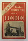
by Nilsson & Co
Nilsson & Co. 12mo. 91pp + 8-page supplement. 2 folding maps of London. Original illustrated covers. Excellent condition except a small tear to rear cover. This German travel guide, published circa 1910, describes tourist attractions in the city of London. A number of images of noteworthy sites are scattered throughout. The back of the guide contains two maps. One is a street map by G.W. Bacon & Co., centered around Regents Park. The other is a map of the London Underground Railways. This particular map marks a transition point in the design of London tube maps: the lines are brightly colored, but the underlying street plan remains as a faded (truncated)

