Carousel content with 1 slides.
A carousel is a rotating set of images, rotation stops on keyboard focus on carousel tab controls or hovering the mouse pointer over images. Use the tabs or the previous and next buttons to change the displayed slide.
")
-
 Slide 1:
-
 Slide 2: no title
 -
 Slide 3: no title
 -
 Slide 4: no title
 -
 Slide 5: no title
 -
 Slide 6: no title
 -
 Slide 7: no title
 -
 Slide 8: no title
 -
 Slide 9: no title
first edition
1666
by NIHON ZU 日本図 [or] NIHON BUNKEI ZU 日本分形圖
1666. 16 hand-tinted woodblock-printed double-page maps. 68 folding leaves. 8vo (193 x 140 mm.), orig. blue semi-stiff wrappers (upper wrapper quite rubbed & wrinkled), modern stitching. From final leaf: [Kyoto]: Nakano Kozaemon 中野小左衛門, 1666.
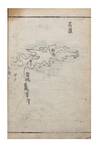
First edition of the first atlas of Japan printed in Japan; this is an extremely rare book. It consists of 16 hand-tinted provincial maps, covering Aomori to Kyūshū and Tsushima. The maps show the extents of the main roads and sea routes. Roadways, towns, castles, rivers, and hot springs are depicted and labelled. The text describes the routes shown on the maps and includes such information (truncated)
First edition of the first atlas of Japan printed in Japan; this is an extremely rare book. It consists of 16 hand-tinted provincial maps, covering Aomori to Kyūshū and Tsushima. The maps show the extents of the main roads and sea routes. Roadways, towns, castles, rivers, and hot springs are depicted and labelled. The text describes the routes shown on the maps and includes such information (truncated)

![A woodblock (201 x 395 x 11 mm.) used to print leaf 19 from series 1 of a Japanese translation of Samuel Smiles’s Self-Help [Saigoku risshihen 西國立志編]; the reverse has a carved grid for composition stationery, two labels on the edges](https://d3525k1ryd2155.cloudfront.net/h/878/553/1687553878.0.m.jpg)